Home > Arts > Artists > O > Abraham Ortelius
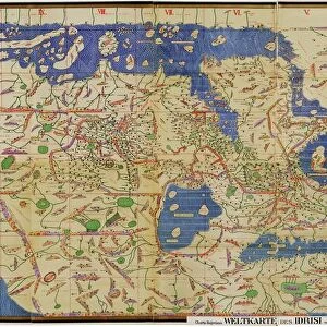
Map of Central and South America. Theatrum Orbis Terrarum by

![]()
Wall Art and Photo Gifts from Mary Evans Picture Library
Map of Central and South America. Theatrum Orbis Terrarum by
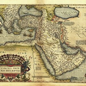
Map of Central and South America. Theatrum Orbis Terrarum by Abraham Ortelius (1527-1598). First Edition. Antwerp, 1574
Mary Evans Picture Library makes available wonderful images created for people to enjoy over the centuries
Media ID 14331728
© Thaliastock / Mary Evans
1574 Abraham Americas Antwerp Atlas Caribbean Carthography Cartographic Cartography Catalonia Continent Edition Flanders Flemish Geography Orbis Ortelius Ortels Terrarum Theatrum
FEATURES IN THESE COLLECTIONS
> Arts
> Artists
> O
> Abraham Ortelius
> Arts
> Artists
> O
> Oceanic Oceanic
> Europe
> Belgium
> Related Images
> Europe
> Spain
> Related Images
> Maps and Charts
> Abraham Ortelius
EDITORS COMMENTS
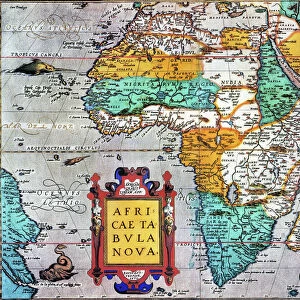
This stunning map print, titled "Theatrum Orbis Terrarum" or "The Theatre of the World," is a masterpiece of cartography from the 16th century. Created by the renowned Flemish cartographer Abraham Ortelius (1527-1598) in Antwerp, Belgium, in 1574, this map is considered the first modern atlas. The intricately detailed map depicts Central and South America, with a focus on the Caribbean region. Ortelius' map showcases the latest geographical knowledge of the time, reflecting the expanding European exploration and colonization of the Americas. The map includes various islands in the Caribbean Sea, the Gulf of Mexico, and the Atlantic Ocean. The detailed rendering of the coastlines, topography, and political divisions of the continents is remarkable for its accuracy, given the challenges of exploration and communication during the 16th century. One of the most striking features of this map is the depiction of ships and vessels navigating the waters, providing a sense of the maritime activity that characterized the Age of Discovery. The map also includes various annotations, such as the names of different regions and countries, as well as the names of explorers and conquerors. This map, which is part of a larger atlas, holds significant historical value as it represents a major milestone in the development of cartography and geographical knowledge. It is a testament to the curiosity and exploration that characterized the early modern period and the desire to understand the world around us. The map is a beautiful and fascinating reminder of the rich history of cartography and the importance of geographical knowledge in shaping our understanding of the world.
MADE IN THE USA
Safe Shipping with 30 Day Money Back Guarantee
FREE PERSONALISATION*
We are proud to offer a range of customisation features including Personalised Captions, Color Filters and Picture Zoom Tools
SECURE PAYMENTS
We happily accept a wide range of payment options so you can pay for the things you need in the way that is most convenient for you
* Options may vary by product and licensing agreement. Zoomed Pictures can be adjusted in the Cart.