Home > Maps and Charts > World
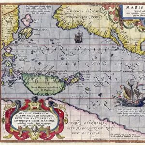
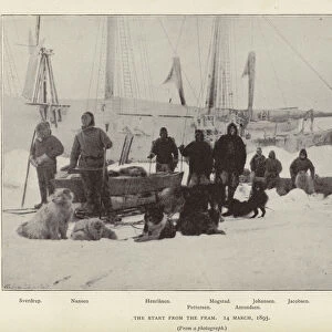
Preliminary Map of the Route of the Fram along Northern Coast of Old World, c1893-1896, (1897)
")
![]()
Wall Art and Photo Gifts from Heritage Images
Preliminary Map of the Route of the Fram along Northern Coast of Old World, c1893-1896, (1897)
Preliminary Map of the Route of the Fram along Northern Coast of Old World, 1893-1896, (1897). From Farthest North, Vol. 1 by Fridtjof Nansen. [Archibald Constable and Company, London, 1897]
Heritage Images features heritage image collections
Media ID 14984035
© The Print Collector
Aged Archibald Constable Archibald Constable And Company Archibald David Archibald David Constable Arctic Constable Expedition Exploration Farthest North Fram Expedition Fridtjof Fridtjof Nansen Journey Nansen Navigation Route World
FEATURES IN THESE COLLECTIONS
> Arts
> Literature
> Maps and Charts
> Related Images
> Maps and Charts
> World
EDITORS COMMENTS
This print showcases the "Preliminary Map of the Route of the Fram along Northern Coast of Old World" dating back to 1893-1896. The aged appearance and artistic charm of this coastal map transport us to a bygone era, where exploration and adventure were at their peak. The vibrant colors and intricate details on this map evoke a sense of wonder and curiosity about the uncharted territories it represents. It serves as a visual testament to the brave journey undertaken by Fridtjof Nansen during his famous Fram expedition in search of new frontiers in the Arctic. As we gaze upon this historical artifact, we are reminded of how literature played an essential role in documenting these groundbreaking expeditions. This particular map is featured in Volume 1 of Nansen's renowned book, "Farthest North". Published by Archibald Constable and Company in London, 1897, it stands as a testament to both scientific exploration and literary achievement. The concept behind this print goes beyond mere navigation; it symbolizes humanity's insatiable thirst for knowledge and our relentless pursuit of discovery. In an age when technology was limited, explorers like Nansen relied on maps like these to navigate treacherous waters with unwavering determination. Let us cherish this remarkable piece from the nineteenth century that encapsulates not only geographical significance but also embodies the spirit of human resilience against nature's harshest elements.
MADE IN THE USA
Safe Shipping with 30 Day Money Back Guarantee
FREE PERSONALISATION*
We are proud to offer a range of customisation features including Personalised Captions, Color Filters and Picture Zoom Tools
SECURE PAYMENTS
We happily accept a wide range of payment options so you can pay for the things you need in the way that is most convenient for you
* Options may vary by product and licensing agreement. Zoomed Pictures can be adjusted in the Cart.