Home > Africa > Egypt > Maps
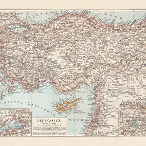
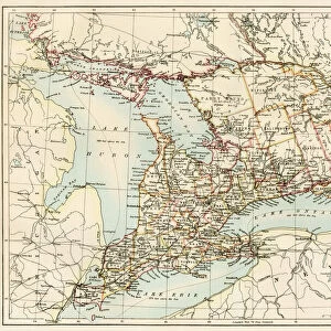
Asia Minor, the Caucasus Region and Mesopotamia, First World War, c1915, (c1920)
")
![]()
Wall Art and Photo Gifts from Heritage Images
Asia Minor, the Caucasus Region and Mesopotamia, First World War, c1915, (c1920)
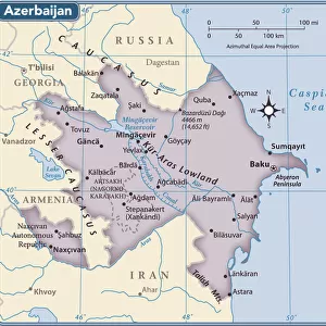
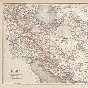
Asia Minor, the Caucasus Region and Mesopotamia, First World War, c1915, (c1920). Map of part of the Middle East, showing eastern Turkey, Cyprus, Syria, Lebanon, Palestine, northern Egypt and the Sinai, Iraq, Azerbaijan, Kurdistan, Georgia and Persia. From " The Great World War - A History" Volume IV, edited by Frank A Mumby. [The Gresham Publishing Company Ltd, London, c1920]
Heritage Images features heritage image collections
Media ID 19175465
© The Print Collector/Heritage Images
Asia Minor Azerbaijan Bartholomew Bartholomew And Co Bartholomew Co Bartholomew John Son Caucasus Caucasus Asia Cypro Cyprus Desert Disputed Territory Frank Arthur Frank Arthur Mumby Georgia Gresham Publishing Co Ltd Gresham Publishing Company Iran Iraq Jg Bartholomew John And Son John Bartholomew And Co John Bartholomew And Son John Bartholomew And Son Ltd John Bartholomew Co John Bartholomew Son John Bartholomew Son Ltd John Son Keystone Archives Kurdistan Lebanon Mediterranean Mesopotamia Mumby Mumby Frank Arthur Palestine Persia Sinai Sinai Egypt Syria Territorial Territory The Great World War A History Theatre Of War Turkey Turkish Mizraim
FEATURES IN THESE COLLECTIONS
> Africa
> Egypt
> Related Images
> Animals
> Mammals
> Muridae
> Desert Mouse
> Arts
> Artists
> S
> Syrian Syrian
> Asia
> Azerbaijan
> Maps
> Asia
> Azerbaijan
> Related Images
> Asia
> Cyprus
> Related Images
> Asia
> Georgia
> Related Images
EDITORS COMMENTS
This print showcases a detailed map titled "Asia Minor, the Caucasus Region and Mesopotamia" during the First World War. Created around 1915 and published in Frank A Mumby's book "The Great World War - A History" this map provides a comprehensive view of the Middle East region at that time. The map encompasses various countries and territories, including eastern Turkey, Cyprus, Syria, Lebanon, Palestine, northern Egypt and the Sinai Peninsula. It also highlights Iraq, Azerbaijan, Kurdistan, Georgia, and Persia (modern-day Iran). The coastal areas along the Mediterranean Sea are beautifully depicted with vibrant colors. The significance of this historical document lies in its portrayal of disputed territories during one of the most tumultuous periods in history. It offers valuable insights into geopolitical boundaries and regional dynamics prevalent during the early 20th century. Created by John Bartholomew & Son – renowned cartographers from Scotland – this map is a testament to their expertise in capturing intricate geographical features with precision. Its inclusion in Mumby's volume adds scholarly value to understanding the impact of World War I on these regions. As we admire this remarkable piece of cartographic artistry today, it serves as a reminder of how borders have shifted over time while highlighting both historical connections and contemporary disputes within Asia Minor, Caucasus Region, and Mesopotamia.
MADE IN THE USA
Safe Shipping with 30 Day Money Back Guarantee
FREE PERSONALISATION*
We are proud to offer a range of customisation features including Personalised Captions, Color Filters and Picture Zoom Tools
SECURE PAYMENTS
We happily accept a wide range of payment options so you can pay for the things you need in the way that is most convenient for you
* Options may vary by product and licensing agreement. Zoomed Pictures can be adjusted in the Cart.