Home > Africa > Angola > Cabinda
DR Congo, satellite image

![]()
Wall Art and Photo Gifts from Science Photo Library
DR Congo, satellite image
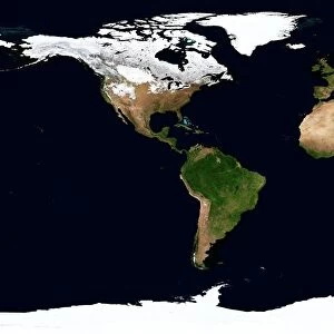
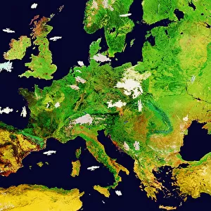
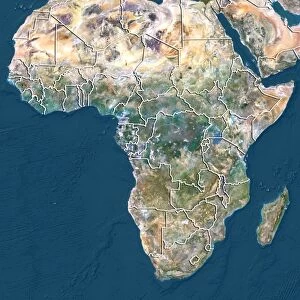
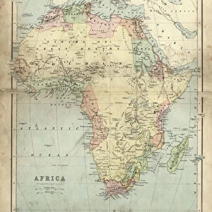
DR Congo. North is at top. Satellite image of the Democratic Republic of the Congo (DRC) in Central Africa, with the surrounding countries shaded out. DRC borders the Central African Republic and South Sudan to the north; Uganda, Rwanda, and Burundi in the east; Zambia and Angola to the south; the Republic of the Congo, the Angolan exclave of Cabinda, and the Atlantic Ocean (blue, left) to the west. Europe (upper centre), the Mediterranean Sea (blue, upper centre), and the Indian Ocean (blue, right) can also be seen. Image compiled from data acquired by LANDSAT satellites, in 2012
Science Photo Library features Science and Medical images including photos and illustrations
Media ID 9217927
© PLANETOBSERVER/SCIENCE PHOTO LIBRARY
2012 Africa Arabian Peninsula Atlantic Ocean Birds Eye View Border Borders Boundaries Boundary Cartography Continent Continents Countries Country Earth Observation Elevation Elevations Environmental From Above From Space Frontier Frontiers Indian Ocean Land Landsat Madagascar Mediterranean Sea Middle East Nation Nations Oceans Satellite Satellite Image Topographic Topography
FEATURES IN THESE COLLECTIONS
> Africa
> Angola
> Related Images
> Africa
> Burundi
> Related Images
> Africa
> Central African Republic
> Maps
> Africa
> Central African Republic
> Related Images
> Africa
> Madagascar
> Maps
> Africa
> Madagascar
> Related Images
> Africa
> Related Images
EDITORS COMMENTS
This print showcases a satellite image of the Democratic Republic of the Congo (DRC) in Central Africa, providing a stunning perspective from above. The vastness and diversity of this landlocked country are beautifully captured, with its neighboring countries shaded out to emphasize its unique features. The DRC shares borders with several nations: the Central African Republic and South Sudan to the north, Uganda, Rwanda, and Burundi in the east, Zambia and Angola to the south, and finally the Republic of Congo along with Angola's exclave Cabinda as well as the Atlantic Ocean on its western side. This comprehensive view also reveals Europe at upper center stage while showcasing both the Mediterranean Sea and Indian Ocean on either side. Compiled from data acquired by LANDSAT satellites in 2012, this image not only highlights geographical aspects but also provides valuable information about elevation and topography. It offers an opportunity for us to appreciate our planet's rich tapestry from space observation. Science Photo Library presents this remarkable piece that encompasses elements such as environment, geography, boundaries between nations or continents while avoiding any commercial use implications. With its detailed cartography capturing elevations and frontiers alike, this print serves as a testament to human innovation in earth observation during our 21st century era.
MADE IN THE USA
Safe Shipping with 30 Day Money Back Guarantee
FREE PERSONALISATION*
We are proud to offer a range of customisation features including Personalised Captions, Color Filters and Picture Zoom Tools
SECURE PAYMENTS
We happily accept a wide range of payment options so you can pay for the things you need in the way that is most convenient for you
* Options may vary by product and licensing agreement. Zoomed Pictures can be adjusted in the Cart.