Home > Battlefields of World War I
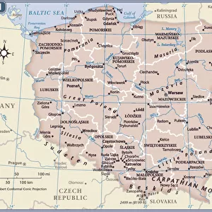
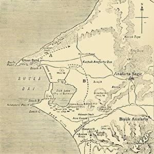
Sketch Map to Illustrate the German Attack north of Warsaw in February, 1915, (c1920)
")
![]()
Wall Art and Photo Gifts from Heritage Images
Sketch Map to Illustrate the German Attack north of Warsaw in February, 1915, (c1920)
Sketch Map to Illustrate the German Attack north of Warsaw in February, 1915, (c1920). Map showing German positions near the Russo-German frontier during the First World War. From " The Great World War - A History" Volume II, edited by Frank A Mumby. [The Gresham Publishing Company Ltd, London, c1920]
Heritage Images features heritage image collections
Media ID 19175275
© The Print Collector/Heritage Images
Border Frank Arthur Frank Arthur Mumby Front Line Frontier Frontline Gresham Publishing Co Ltd Gresham Publishing Company Keystone Archives Mumby Mumby Frank Arthur Poland Position Positions Railway Line Railway Track Railway Tracks Territorial Territory The Great World War A History Theatre Of War Train Track Warsaw Warsaw Poland Battlefield
FEATURES IN THESE COLLECTIONS
> Europe
> Poland
> Related Images
> Europe
> United Kingdom
> England
> London
> Art
> Theatre
EDITORS COMMENTS
This print titled "Sketch Map to Illustrate the German Attack north of Warsaw in February, 1915" takes us back to a significant moment during the First World War. The map, featured in the book "The Great World War - A History" provides valuable insights into the positioning of German forces near the Russo-German frontier. As we delve into this historical artifact, we can observe intricate details that highlight the strategic importance of Warsaw and its surroundings during this period. The railway tracks depicted on the map symbolize not only transportation but also serve as a reminder of how crucial railways were for military operations at that time. The image captures an era when countries fought fiercely for territorial control, with Germany making its move towards Warsaw. This sketch map serves as a visual representation of their advancement and highlights key positions along their route. Authored by Frank A Mumby and published by The Gresham Publishing Company Ltd in London around 1920, this piece offers us a glimpse into one theater of war during World War I. It is fascinating to witness how cartography was utilized to document military movements and understand complex battle strategies. This print from Heritage Images allows us to appreciate both the historical significance and artistic value embedded within it. It stands as a testament to human conflict while reminding us of our collective responsibility to learn from history's lessons.
MADE IN THE USA
Safe Shipping with 30 Day Money Back Guarantee
FREE PERSONALISATION*
We are proud to offer a range of customisation features including Personalised Captions, Color Filters and Picture Zoom Tools
SECURE PAYMENTS
We happily accept a wide range of payment options so you can pay for the things you need in the way that is most convenient for you
* Options may vary by product and licensing agreement. Zoomed Pictures can be adjusted in the Cart.