Home > Animals > Mammals > Cats (Wild) > Populator
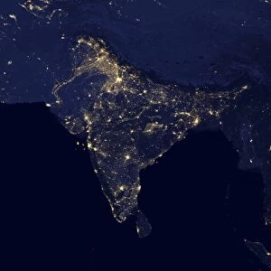
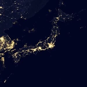
Africa at night, satellite image

![]()
Wall Art and Photo Gifts from Science Photo Library
Africa at night, satellite image
Africa at night. Black marble satellite image of Africa at night. More densely populated areas are brighter. The Nile is illuminated by the many boats along its length. The nocturnal glow produced by the Earths atmosphere is shown as well as man-made light. Data acquired by the day-night band of the Visible Infrared Imaging Radiometer Suite (VIIRS) on board the NASA-NOa Suomi National Polar-orbiting Partnership (NPP) satellite, over nine days in April 2012 and 13 days in October 2012
Science Photo Library features Science and Medical images including photos and illustrations
Media ID 9221527
© NASA EARTH OBSERVATORY/NOAA NGDC/SCIENCE PHOTO LIBRARY
2012 Africa African Black Marble Cities City Composite Image Continent Dark Day Night Band Earth Observation Electricity Energy Use Flat Projection From Space Habitation Illuminate Illumination Land Light Light Pollution Lights Night Night Time Nile Nile Delta Population Density River Rural Satellite Satellite Image Suomi Npp Urban Viirs
FEATURES IN THESE COLLECTIONS
> Africa
> Related Images
> Animals
> Mammals
> Cats (Wild)
> Populator
> Arts
> Landscape paintings
> Waterfall and river artworks
> River artworks
> Europe
> France
> Canton
> Landes
> Maps and Charts
> Flat Earth
> Science
> Space Exploration
> Related Images
> Science
> Space Exploration
> Satellite Imagery
EDITORS COMMENTS
This print captures the mesmerizing beauty of Africa at night, as seen from space. The black marble satellite image showcases the continent in all its glory, with brighter areas indicating higher population density. Along the length of the Nile River, a radiant glow illuminates its waters due to countless boats dotting its surface. The image not only reveals man-made light but also showcases the nocturnal glow produced by Earth's atmosphere. Acquired over nine days in April 2012 and thirteen days in October 2012, this composite image was captured by NASA-NOa Suomi National Polar-orbiting Partnership (NPP) satellite's day-night band of Visible Infrared Imaging Radiometer Suite (VIIRS). As we gaze upon this breathtaking snapshot from space, it becomes evident how human habitation and energy use have shaped Africa's landscape. From bustling cities to remote rural areas, every corner tells a unique story through varying levels of illumination. The flat projection highlights Africa's diverse topography while shedding light on light pollution across the continent. This remarkable visual representation allows us to appreciate both the natural wonders and urban developments that define Africa in the 21st century. With each passing moment captured by satellites like VIIRS, our understanding of Earth deepens as we witness its ever-changing dynamics unfold before our eyes.
MADE IN THE USA
Safe Shipping with 30 Day Money Back Guarantee
FREE PERSONALISATION*
We are proud to offer a range of customisation features including Personalised Captions, Color Filters and Picture Zoom Tools
SECURE PAYMENTS
We happily accept a wide range of payment options so you can pay for the things you need in the way that is most convenient for you
* Options may vary by product and licensing agreement. Zoomed Pictures can be adjusted in the Cart.