Home > Aerial Photography > Related Images
Albuquerque New Mexico US City Street Map

![]()
Wall Art and Photo Gifts from Fine Art Storehouse
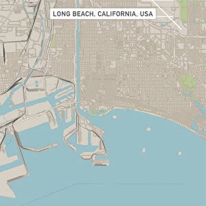
Albuquerque New Mexico US City Street Map
Vector Illustration of a City Street Map of Albuquerque, New Mexico, USA. Scale 1:60, 000.
All source data is in the public domain.
U.S. Geological Survey, US Topo
Used Layers:
USGS The National Map: National Hydrography Dataset (NHD)
USGS The National Map: National Transportation Dataset (NTD)
Unleash your creativity and transform your space into a visual masterpiece!
Frank Ramspott
Media ID 15215832
© Frank Ramspott, all rights reserved
Aerial View City Map Computer Graphic Directly Above Downtown District Gray New Mexico Road Map Text Albuquerque Digitally Generated Image Green Color Rio Grande White Color
FEATURES IN THESE COLLECTIONS
> Aerial Photography
> Related Images
> Animals
> Insects
> Hemiptera
> Green Scale
> Arts
> Contemporary art
> Digital artwork
> Street art
> Arts
> Landscape paintings
> Waterfall and river artworks
> River artworks
> Arts
> Portraits
> Pop art gallery
> Street art portraits
> Arts
> Street art graffiti
> Digital art
> Digital paintings
> Arts
> Street art graffiti
> Digital art
> Vector illustrations
> Fine Art Storehouse
> Map
> Street Maps
> Fine Art Storehouse
> Map
> USA Maps
> Maps and Charts
> Geological Map
> Maps and Charts
> Related Images
> North America
> Mexico
> Lakes
> Related Images
EDITORS COMMENTS
This print showcases a meticulously detailed city street map of Albuquerque, New Mexico, USA. Created as a vector illustration with a scale of 1:60,000, this artwork offers an immersive exploration of the city's layout and features. The source data used in its creation is from the public domain and includes information from the U. S. Geological Survey's National Hydrography Dataset (NHD) and National Transportation Dataset (NTD). The image depicts various elements that make Albuquerque unique, such as the iconic Rio Grande flowing through the downtown district. A lake can also be seen alongside the river, adding to the scenic beauty of this vibrant city. The intricate network of streets and roads is clearly visible on this map, providing valuable insights for navigation purposes. Designed using computer graphics technology, this digitally generated image boasts an aerial view directly above Albuquerque. Its color scheme combines shades of gray with pops of blue, white, and green to enhance readability and visual appeal. Perfectly suited for cartography enthusiasts or anyone seeking to appreciate Albuquerque's physical geography at a glance, this print by Frank Ramspott captures both artistry and functionality in one stunning composition. Note that it does not feature people but focuses solely on showcasing the city's remarkable urban landscape.
MADE IN THE USA
Safe Shipping with 30 Day Money Back Guarantee
FREE PERSONALISATION*
We are proud to offer a range of customisation features including Personalised Captions, Color Filters and Picture Zoom Tools
SECURE PAYMENTS
We happily accept a wide range of payment options so you can pay for the things you need in the way that is most convenient for you
* Options may vary by product and licensing agreement. Zoomed Pictures can be adjusted in the Cart.