Home > Aerial Photography > Related Images
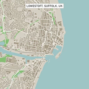
Provo Utah US City Street Map

![]()
Wall Art and Photo Gifts from Fine Art Storehouse
Provo Utah US City Street Map
Vector Illustration of a City Street Map of Provo, Utah, USA. Scale 1:60, 000.
All source data is in the public domain.
U.S. Geological Survey, US Topo
Used Layers:
USGS The National Map: National Hydrography Dataset (NHD)
USGS The National Map: National Transportation Dataset (NTD)
Unleash your creativity and transform your space into a visual masterpiece!
Frank Ramspott
Media ID 15054971
© Frank Ramspott, all rights reserved
Aerial View City Map Computer Graphic Directly Above Downtown District Gray Road Map Text Utah Digitally Generated Image Green Color Provo White Color
FEATURES IN THESE COLLECTIONS
> Aerial Photography
> Related Images
> Animals
> Insects
> Hemiptera
> Green Scale
> Arts
> Contemporary art
> Digital artwork
> Street art
> Arts
> Landscape paintings
> Waterfall and river artworks
> River artworks
> Arts
> Portraits
> Pop art gallery
> Street art portraits
> Arts
> Street art graffiti
> Digital art
> Digital paintings
> Arts
> Street art graffiti
> Digital art
> Vector illustrations
> Fine Art Storehouse
> Map
> Street Maps
> Fine Art Storehouse
> Map
> USA Maps
> Maps and Charts
> Geological Map
> Maps and Charts
> Related Images
> North America
> United States of America
> Lakes
> Related Images
EDITORS COMMENTS
This print showcases a meticulously detailed city street map of Provo, Utah, USA. With a scale of 1:60,000, every intricate feature is brought to life in this vector illustration. The artist, Frank Ramspott, skillfully utilized various layers from the USGS National Map including the National Hydrography Dataset and National Transportation Dataset to create this stunning piece. The image captures the essence of Provo with its vibrant downtown district nestled between Provo Bay and Utah Lake. A meandering river adds an element of natural beauty to the city's landscape. Roads crisscross throughout the map, providing a comprehensive view of the city's transportation network. Rendered in shades of gray, blue, white, and green colors against a texturized background; this digitally generated artwork exudes both artistic flair and cartographic precision. The aerial perspective allows viewers to appreciate every detail from directly above. Perfect for enthusiasts of maps or those with an affinity for Provo's physical geography, this print is an ideal addition to any home or office decor. It serves as a reminder that even within urban landscapes lie hidden wonders waiting to be explored.
MADE IN THE USA
Safe Shipping with 30 Day Money Back Guarantee
FREE PERSONALISATION*
We are proud to offer a range of customisation features including Personalised Captions, Color Filters and Picture Zoom Tools
SECURE PAYMENTS
We happily accept a wide range of payment options so you can pay for the things you need in the way that is most convenient for you
* Options may vary by product and licensing agreement. Zoomed Pictures can be adjusted in the Cart.