Home > Aerial Photography > Related Images
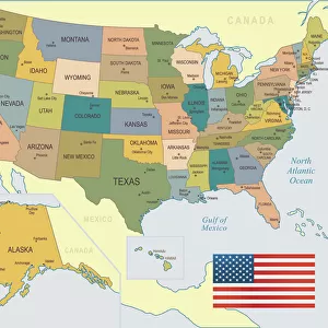
Minot North Dakota US City Street Map

![]()
Wall Art and Photo Gifts from Fine Art Storehouse
Minot North Dakota US City Street Map
Vector Illustration of a City Street Map of Minot, North Dakota, USA. Scale 1:60, 000.
All source data is in the public domain.
U.S. Geological Survey, US Topo
Used Layers:
USGS The National Map: National Hydrography Dataset (NHD)
USGS The National Map: National Transportation Dataset (NTD)
Unleash your creativity and transform your space into a visual masterpiece!
Frank Ramspott
Media ID 15215826
© Frank Ramspott, all rights reserved
Aerial View City Map Computer Graphic Directly Above Downtown District Gray North Dakota Road Map Text Digitally Generated Image Green Color Minot White Color
FEATURES IN THESE COLLECTIONS
> Aerial Photography
> Related Images
> Animals
> Insects
> Hemiptera
> Green Scale
> Arts
> Contemporary art
> Digital artwork
> Street art
> Arts
> Landscape paintings
> Waterfall and river artworks
> River artworks
> Arts
> Portraits
> Pop art gallery
> Street art portraits
> Arts
> Street art graffiti
> Digital art
> Digital paintings
> Arts
> Street art graffiti
> Digital art
> Vector illustrations
> Fine Art Storehouse
> Map
> Street Maps
> Fine Art Storehouse
> Map
> USA Maps
> Maps and Charts
> Geological Map
> Maps and Charts
> Related Images
> North America
> United States of America
> Lakes
> Related Images
EDITORS COMMENTS
This print showcases a meticulously detailed city street map of Minot, North Dakota, USA. With a scale of 1:60,000, every intricate feature is brought to life in this vector illustration. The source data used for this artwork is in the public domain and comes from the U. S. Geological Survey's National Map, specifically their National Hydrography Dataset (NHD) and National Transportation Dataset (NTD). The image encompasses various elements that define Minot's landscape and character. From the meandering Souris River to the vibrant downtown district, every road and street is intricately depicted on this map. The inclusion of lakes adds depth to the composition while highlighting important water bodies within the area. Designed with precision and digitally generated by Frank Ramspott, this aerial view captures Minot directly from above. The color palette chosen for this piece includes shades of gray, blue, white, and green which beautifully complement each other. With no people present in the image itself but accompanied by text providing essential information about its content and origin; it serves as both an artistic representation of Minot's physical geography as well as a practical tool for navigation
MADE IN THE USA
Safe Shipping with 30 Day Money Back Guarantee
FREE PERSONALISATION*
We are proud to offer a range of customisation features including Personalised Captions, Color Filters and Picture Zoom Tools
SECURE PAYMENTS
We happily accept a wide range of payment options so you can pay for the things you need in the way that is most convenient for you
* Options may vary by product and licensing agreement. Zoomed Pictures can be adjusted in the Cart.