Home > Europe > United Kingdom > England > Durham > Bedburn
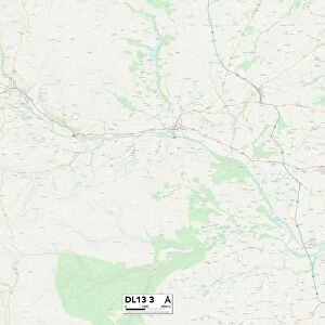
County Durham DL13 3 Map

![]()
Wall Art and Photo Gifts from Map Marketing
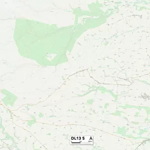
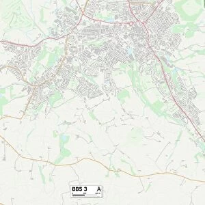
County Durham DL13 3 Map
Postcode Sector Map of County Durham DL13 3
Media ID 19968508
A689 Church Lane County Durham Crook Lane Deneside Durham Road East End Ferndale Front Street Gordon Terrace Greenways High Street Ladywell Leazes Lane Melbourne Place Rectory Lane Riverside Silver Street St Annes Drive Stanhope Road The Causeway The Crofts The Garth West End Gateways Holywood Redford Upper Town
FEATURES IN THESE COLLECTIONS
> Europe
> United Kingdom
> England
> County Durham
> Crook
> Europe
> United Kingdom
> England
> County Durham
> Durham
> Europe
> United Kingdom
> England
> County Durham
> Stanhope
> Europe
> United Kingdom
> England
> County Durham
> Wolsingham
> Europe
> United Kingdom
> England
> Durham
> Bedburn
> Europe
> United Kingdom
> England
> Durham
> Crook
> Europe
> United Kingdom
> England
> Durham
> Deneside
> Europe
> United Kingdom
> England
> Durham
> Durham
> Europe
> United Kingdom
> England
> Durham
> Hamsterley
> Europe
> United Kingdom
> England
> Durham
> Hill End
> Map Marketing
> Postcode Sector Maps
> DL - Darlington
MADE IN THE USA
Safe Shipping with 30 Day Money Back Guarantee
FREE PERSONALISATION*
We are proud to offer a range of customisation features including Personalised Captions, Color Filters and Picture Zoom Tools
SECURE PAYMENTS
We happily accept a wide range of payment options so you can pay for the things you need in the way that is most convenient for you
* Options may vary by product and licensing agreement. Zoomed Pictures can be adjusted in the Cart.