Home > Europe > United Kingdom > England > London > Boroughs > City of London
The Plantation of Ulster, 17th century, (1948). Creator: Unknown
. Creator: Unknown")
![]()
Wall Art and Photo Gifts from Heritage Images
The Plantation of Ulster, 17th century, (1948). Creator: Unknown
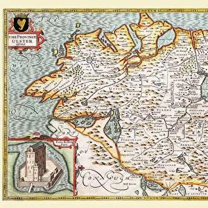
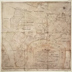
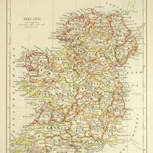
The Plantation of Ulster, 17th century, (1948). Map: Plan of lands belonging to the Companies of London in Ireland. The Plantation of Ulster was the organised colonisation (plantation) of a province of Ireland by people from Great Britain during the reign of King James I. The livery companies of the City of London were coerced into investing in the project. Originally published in " A Survey of Irish Plantation" by Sir Thomas Phillips, [1662]. From " The Guilds of the City of London", by Sir Ernest Pooley. [Collins, London, 1948]
Heritage Images features heritage image collections
Media ID 18385226
© The Print Collector/Heritage Images
1st Baronet Colonisation Ernest Ernest Henry Ernest Henry Pooley Ernest Pooley Guild Ireland Livery Company Northern Ireland Phillips Pooley Sir Ernest Henry Pooley Sir Ernest Pooley Territorial Territory Thomas Phillips Ulster
FEATURES IN THESE COLLECTIONS
> Animals
> Mammals
> Muridae
> Fortior
> Arts
> Artists
> H
> Thomas Henry
> Arts
> Artists
> P
> Thomas Phillips
> Arts
> Literature
> Europe
> Republic of Ireland
> Maps
> Europe
> United Kingdom
> England
> London
> Boroughs
> City of London
> Europe
> United Kingdom
> England
> Maps
> Europe
> United Kingdom
> Northern Ireland
> Maps
> Europe
> United Kingdom
> Northern Ireland
> Posters
> Europe
> United Kingdom
> Northern Ireland
> Related Images
EDITORS COMMENTS
This print showcases "The Plantation of Ulster, 17th century" which was created by an unknown artist in 1948. The image features a detailed map titled "Plan of lands belonging to the Companies of London in Ireland" originally published in Sir Thomas Phillips' renowned work "A Survey of Irish Plantation" from 1662. This historical event refers to the organised colonisation or plantation of a province in Ireland during King James I's reign, with settlers arriving from Great Britain. The livery companies of the City of London were coerced into investing in this ambitious project, as depicted on this fascinating map. The print is part of Sir Ernest Pooley's book "The Guilds of the City of London" published by Collins in 1948. With its vibrant colors and intricate details, this print transports viewers back to the seventeenth century when colonialism and territorial expansion were prevalent themes across Europe. It serves as a reminder not only of England's influence but also highlights the complex history between Britain and Ireland. As we delve into this visual representation, it becomes evident that this piece holds immense historical value for scholars, art enthusiasts, and those interested in understanding Northern Ireland's past. Through examining maps like these, we gain insight into trade routes, land ownership patterns, and how power dynamics shaped nations throughout centuries gone by.
MADE IN THE USA
Safe Shipping with 30 Day Money Back Guarantee
FREE PERSONALISATION*
We are proud to offer a range of customisation features including Personalised Captions, Color Filters and Picture Zoom Tools
SECURE PAYMENTS
We happily accept a wide range of payment options so you can pay for the things you need in the way that is most convenient for you
* Options may vary by product and licensing agreement. Zoomed Pictures can be adjusted in the Cart.