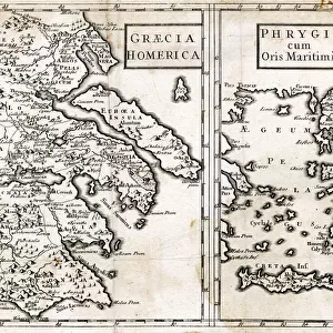
1794, Anville Map of Ancient Greece, topography, cartography, geography, land, illustration

![]()
Wall Art and Photo Gifts from Liszt Collection
1794, Anville Map of Ancient Greece, topography, cartography, geography, land, illustration
1794, Anville Map of Ancient Greece
Liszt Collection of nineteenth-century engravings and images to browse and enjoy
Media ID 14006863
© Artokoloro Quint Lox Limited
1794 Antique Map Latitude Longitude Mappa Mundi Old Antique Plan Old Antique View Ols Antique Map Rare Old Maps Topo
EDITORS COMMENTS
This print showcases the exquisite "1794, Anville Map of Ancient Greece" a true masterpiece in the realms of topography, cartography, and geography. The intricate details depicted on this vintage map transport us back to an era where exploration and discovery were at their peak. With its precise land illustrations and meticulous geographic markings, this ancient artifact offers a fascinating glimpse into the world as it was centuries ago. The aged paper exudes an air of history and adds to the charm of this decorative piece. Its retro aesthetic evokes a sense of nostalgia for times long gone by. As we gaze upon this remarkable illustration, we can't help but be reminded of the countless journeys embarked upon by intrepid explorers who relied on maps like these to navigate uncharted territories. The use of latitude and longitude grids further enhances our understanding of how early civilizations perceived their place within the vastness of Earth's landscape. This rare old map is not only a testament to human ingenuity but also serves as a valuable historical document that allows us to trace the evolution of ancient Greek civilization. Whether you are an avid collector or simply appreciate art with historical significance, this Anville Map print from Liszt Collection will undoubtedly captivate your imagination with its rich narrative and timeless beauty.
MADE IN THE USA
Safe Shipping with 30 Day Money Back Guarantee
FREE PERSONALISATION*
We are proud to offer a range of customisation features including Personalised Captions, Color Filters and Picture Zoom Tools
SECURE PAYMENTS
We happily accept a wide range of payment options so you can pay for the things you need in the way that is most convenient for you
* Options may vary by product and licensing agreement. Zoomed Pictures can be adjusted in the Cart.