Home > Fine Art Storehouse > Map
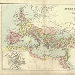
Victorian Map of The Roman Empire

![]()
Wall Art and Photo Gifts from Fine Art Storehouse
Victorian Map of The Roman Empire
Engraved illustrations of the Roman Empire Under Constantine the Great from Iconographic Encyclopedia of Science, Literature and Art, Published in 1851. Copyright has expired on this artwork. Digitally restored
Unleash your creativity and transform your space into a visual masterpiece!
bauhaus1000
Media ID 13666979
© Craig McCausland
1850 1859 Ancient Rome Austria Belgium Chart Country Geographic Area Diagram Drypoint Empire European Culture Greece Image Created 1850 1859 Isolated Isolated On White Northern Ireland Plan Republic Of Ireland Roman Steel Engraving World Map Drawing Art Product Image Created 19th Century Roman Culture Victorian Style
FEATURES IN THESE COLLECTIONS
> Fine Art Storehouse
> Map
> Historical Maps
> Fine Art Storehouse
> Map
> Italian Maps
EDITORS COMMENTS
This print showcases a meticulously engraved Victorian map of the Roman Empire, offering a glimpse into the ancient world under Constantine the Great. Published in 1851 as part of an Iconographic Encyclopedia of Science, Literature and Art, this artwork has been digitally restored to its former glory. The copyright on this piece has expired, allowing us to appreciate and admire its intricate details. The print transports us back to the 19th century with its distinctive style and craftsmanship. It beautifully combines cartography, history, and artistry to create a visually stunning representation of European culture during ancient times. From Spain to Italy, Greece to Austria, Belgium to France – all these countries are intricately depicted within the empire's vast borders. With no people in sight but surrounded by white space, this isolated image draws our attention solely towards its rich content. The steel engraving technique used adds depth and texture while highlighting every contour of landmasses and bodies of water. As we explore this remarkable illustration further, we can't help but marvel at how it captures not only physical geography but also aspects of Roman culture that shaped Europe's history. This print serves as both an educational tool for understanding ancient civilizations and a beautiful piece of art that evokes nostalgia for a bygone era. Whether you're passionate about travel or fascinated by historical maps, this Victorian masterpiece is sure to captivate your imagination with its timeless charm.
MADE IN THE USA
Safe Shipping with 30 Day Money Back Guarantee
FREE PERSONALISATION*
We are proud to offer a range of customisation features including Personalised Captions, Color Filters and Picture Zoom Tools
SECURE PAYMENTS
We happily accept a wide range of payment options so you can pay for the things you need in the way that is most convenient for you
* Options may vary by product and licensing agreement. Zoomed Pictures can be adjusted in the Cart.