Home > Animals > Mammals > Cats (Domestic) > Scottish Fold
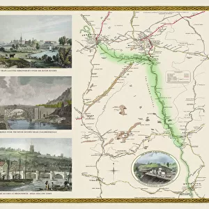
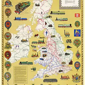
Pictorial History Railway Map of Britain

![]()
Wall Art and Photo Gifts from MapSeeker
Pictorial History Railway Map of Britain
This is a wonderful large format pictorial map illustrating the history of the Railways of Britain up to its original publication date of 1974. Drawn by Laurence Richardson and last published in 1974 by Collins Bartholomew as a fold up map. Now re-digitized and re-published by Mapseeker in association with the Collins Bartholomew Archive, the map covers all of England, Wales, Scotland and Ireland with various historical events, progress, iconic steam locomotives, heritage railways illustrated pictorially in the form of eye catching vignettes. The map is surrounded by the crests of many of the Railway Companies that were founded over time until they were consumed under the Amalgamation of 1923
Welcome to the Mapseeker Image library and enter an historic gateway to one of the largest on-line collections of Historic Maps, Nostalgic Views, Vista's and Panorama's from a World gone by.
Media ID 20347943
© reserved
FEATURES IN THESE COLLECTIONS
> Animals
> Mammals
> Cats (Domestic)
> Scottish Fold
> Europe
> Republic of Ireland
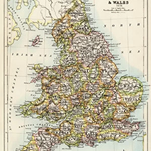
> Maps
> Europe
> United Kingdom
> England
> Maps
> Europe
> United Kingdom
> England
> Railways
> Europe
> United Kingdom
> Scotland
> Maps
> Europe
> United Kingdom
> Scotland
> Railways
> Europe
> United Kingdom
> Wales
> Maps
> Europe
> United Kingdom
> Wales
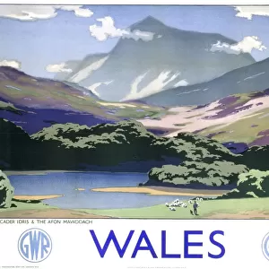
> Posters
> Europe
> United Kingdom
> Wales
> Railways
> Europe
> United Kingdom
> Wales
> Related Images
> MapSeeker
> Pictorial Maps and Pictorial History
> Pictorial History Maps PORTFOLIO
EDITORS COMMENTS
This print showcases the remarkable "Pictorial History Railway Map of Britain". Originally crafted by Laurence Richardson and last published in 1974, this large format map has been meticulously re-digitized and re-published by Mapseeker in collaboration with the esteemed Collins Bartholomew Archive. Spanning across England, Wales, Scotland, and Ireland, this exquisite map offers a visual journey through the rich history of British railways up until its publication date. The map is adorned with an array of eye-catching vignettes that vividly illustrate various historical events, milestones in progress, as well as iconic steam locomotives and heritage railways. Surrounding these captivating visuals are the crests of numerous railway companies that once flourished before being amalgamated under the historic Amalgamation Act of 1923. With its intricate details and nostalgic charm, this print serves as a testament to Britain's enduring love affair with trains. It allows viewers to immerse themselves in a bygone era when railways were at their zenith – connecting towns and cities while shaping the nation's industrial landscape. Whether you are an avid train enthusiast or simply appreciate British history, this extraordinary pictorial map is sure to captivate your imagination. Let it transport you back in time as you marvel at the evolution of one of Britain's most cherished modes of transportation.
MADE IN THE USA
Safe Shipping with 30 Day Money Back Guarantee
FREE PERSONALISATION*
We are proud to offer a range of customisation features including Personalised Captions, Color Filters and Picture Zoom Tools
SECURE PAYMENTS
We happily accept a wide range of payment options so you can pay for the things you need in the way that is most convenient for you
* Options may vary by product and licensing agreement. Zoomed Pictures can be adjusted in the Cart.