Home > Arts > Artists > S > John Speed
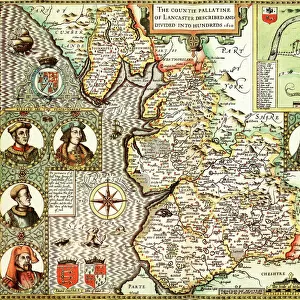
Old County Map of Staffordshire 1611 by John Speed

![]()
Wall Art and Photo Gifts from MapSeeker
Old County Map of Staffordshire 1611 by John Speed
A facimile of John Speeds historical map of Staffordshire originally published for the " Theatre of the Empire of Great Britain", an atlas to accompany " a history of Great Britain"
Welcome to the Mapseeker Image library and enter an historic gateway to one of the largest on-line collections of Historic Maps, Nostalgic Views, Vista's and Panorama's from a World gone by.
Media ID 20347558
© Mapseeker Publishing Ltd
County Map County Map Of England English County Map Historic Map John Speed Map Old County Map Old English County Map Speed Map Speede Map Staffordshire
FEATURES IN THESE COLLECTIONS
> Arts
> Artists
> S
> John Speed
> Europe
> United Kingdom
> England
> Maps
> Europe
> United Kingdom
> England
> Staffordshire
> Related Images
> Maps and Charts
> British Empire Maps
> Maps and Charts
> Early Maps
> MapSeeker
> Maps from the British Isles
> England and Counties PORTFOLIO
EDITORS COMMENTS
This print showcases the "Old County Map of Staffordshire 1611" by John Speed, a renowned cartographer of his time. Originally published for the "Theatre of the Empire of Great Britain" an atlas accompanying a comprehensive history of Great Britain, this facsimile offers us a glimpse into the rich historical heritage of Staffordshire. With intricate details and expert craftsmanship, Speed's map provides an invaluable window into the past. Every line and curve on this English county map tells a story, revealing the evolving landscape and settlements that once shaped Staffordshire. From bustling towns to serene countryside, it paints a vivid picture of life in early 17th-century England. As we explore this historic treasure, we are transported back in time to an era where maps were not just navigational tools but works of art. The careful placement of rivers, roads, and landmarks reflects Speed's dedication to accuracy while also showcasing his artistic flair. Staffordshire itself comes alive through this map; its boundaries clearly defined as if inviting us to delve deeper into its hidden treasures. Whether you have personal ties to this county or simply appreciate historical cartography, this print is sure to captivate your imagination and spark curiosity about our shared past. Let John Speed's masterpiece adorn your walls as a testament to both his skill as a cartographer and Staffordshire's enduring legacy throughout history.
MADE IN THE USA
Safe Shipping with 30 Day Money Back Guarantee
FREE PERSONALISATION*
We are proud to offer a range of customisation features including Personalised Captions, Color Filters and Picture Zoom Tools
SECURE PAYMENTS
We happily accept a wide range of payment options so you can pay for the things you need in the way that is most convenient for you
* Options may vary by product and licensing agreement. Zoomed Pictures can be adjusted in the Cart.