Home > Europe > United Kingdom > Scotland > Bute
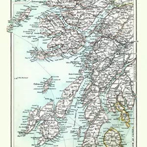
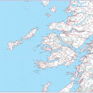
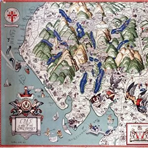
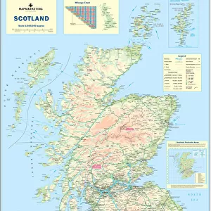
Map of Argyllshire, 1924-1926

![]()
Wall Art and Photo Gifts from Heritage Images
Map of Argyllshire, 1924-1926
Map of Argyllshire, 1924-1926. The Western Isles including Islay, Jura and Mull. Illustration from Hutchinsons Britain Beautiful, edited by Walter Hutchinson, volume I, (Hutchinson and Co, 1924-1926)
Heritage Images features heritage image collections
Media ID 14942673
© The Print Collector / Heritage-Images
Argyll And Bute Hebrides Island Islay Mull Argyllshire Isle Of Mull Print Collector8
FEATURES IN THESE COLLECTIONS
> Animals
> Mammals
> Muridae
> Western Mouse
> Europe
> United Kingdom
> Scotland
> Argyll
> Europe
> United Kingdom
> Scotland
> Bute
> Europe
> United Kingdom
> Scotland
> Maps
> Europe
> United Kingdom
> Scotland
> Posters
> Europe
> United Kingdom
> Scotland
> Related Images
> Europe
> United Kingdom
> Scotland
> Western Isles
> Related Images
> Maps and Charts
> Related Images
EDITORS COMMENTS
This print showcases a beautifully detailed "Map of Argyllshire, 1924-1926". The map encompasses the Western Isles, including the enchanting Islay, Jura, and Mull. It was originally featured in the esteemed publication "Hutchinsons Britain Beautiful" edited by Walter Hutchinson. This particular illustration can be found in volume I of the book, which was published between 1924 and 1926 by Hutchinson and Co. The vibrant colors used to depict this coastal region of Scotland truly bring it to life. With its picturesque landscapes and charming islands scattered throughout, Argyllshire is a sight to behold. The map not only provides geographical information but also offers a glimpse into the country's rich history. One cannot help but marvel at the intricate details that make up this early 20th-century masterpiece. From tiny villages nestled along the coastlines to rolling hills and rugged cliffs, every corner of Argyllshire is meticulously represented. The inclusion of Mull Island adds an extra layer of allure to this already captivating composition. As one explores this map print further, they will uncover fascinating insights into Argyle and Bute as well as Islay - all part of Scotland's breathtaking Hebrides archipelago. This extraordinary print serves as both an informative resource for geography enthusiasts and a stunning piece of art that transports viewers back in time to experience Scotland's natural beauty firsthand.
MADE IN THE USA
Safe Shipping with 30 Day Money Back Guarantee
FREE PERSONALISATION*
We are proud to offer a range of customisation features including Personalised Captions, Color Filters and Picture Zoom Tools
SECURE PAYMENTS
We happily accept a wide range of payment options so you can pay for the things you need in the way that is most convenient for you
* Options may vary by product and licensing agreement. Zoomed Pictures can be adjusted in the Cart.