Home > Maps and Charts > Willem Janszoon Blaeu
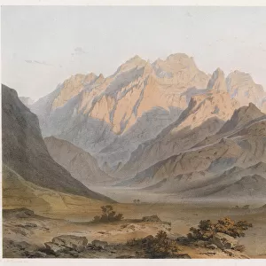
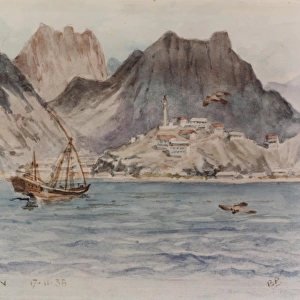
Atlas Novus. Asia, 17th c Aden

![]()
Wall Art and Photo Gifts from Mary Evans Picture Library
Atlas Novus. Asia, 17th c Aden
BLAEU, Jan (1596-1673). Atlas Novus or Atlas Maior. 1635 - 1665. Asia noviter delineata. Map of Asia printed in Amsterdam ca. 1635. Detail with view of the city of Aden. Etching. SPAIN. CATALONIA. Barcelona. Biblioteca de Catalunya (National Library of Catalonia)
Mary Evans Picture Library makes available wonderful images created for people to enjoy over the centuries
Media ID 14179462
© Iberfoto/Mary Evans
1571 1596 1635 1638 1665 1673 Aden Amsterdam Atlas Barcelona Biblioteca Blaeu Catalonia Catalunya Cliff Cliffs Delineata Engravings Etching Etchings Janszoon Maior Monde Noviter Novus Peninsula Range Willem
EDITORS COMMENTS
This detail is taken from the intricately crafted map of Asia, titled "Asia noviter delineata" or "Newly Drawn Asia," which is a part of the monumental atlas work "Atlas Novus" or "Atlas Maior" by the renowned Flemish cartographer Jan Blaeu. The map was produced in Amsterdam around 1635, with this particular detail showcasing the bustling port city of Aden, located on the southwestern coast of the Arabian Peninsula. The map's meticulous etching reveals the city's strategic position at the entrance of the Red Sea, with its natural harbor and defensive walls protecting it from the harsh waters and potential invaders. The map also highlights the surrounding topography, including the rugged cliffs, bays, and mountain ranges that characterize the region. The islands scattered in the nearby waters are also depicted with remarkable accuracy. The map's rich detail and stunning visual representation of the world were the result of extensive research and collaboration between Blaeu and other prominent cartographers and geographers of the time, such as Willem Janszoon and William Cliff. This map was created during the 17th century, a time when European exploration and colonization of the world were at their height. The "Atlas Novus" was a significant contribution to the advancement of cartography and geographical knowledge during this period. Today, this rare and beautiful map is preserved in the Biblioteca de Catalunya (National Library of Catalonia) in Barcelona, Spain.
MADE IN THE USA
Safe Shipping with 30 Day Money Back Guarantee
FREE PERSONALISATION*
We are proud to offer a range of customisation features including Personalised Captions, Color Filters and Picture Zoom Tools
SECURE PAYMENTS
We happily accept a wide range of payment options so you can pay for the things you need in the way that is most convenient for you
* Options may vary by product and licensing agreement. Zoomed Pictures can be adjusted in the Cart.