Home > Europe > United Kingdom > England > London > Towns > Welling
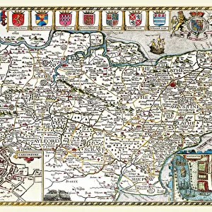
Old County Map of Devonshire 1836 by Thomas Moule

![]()
Wall Art and Photo Gifts from MapSeeker
Old County Map of Devonshire 1836 by Thomas Moule
This is a fine decorative reproduction County Map of Devonshire from the First Edition series of Thomas Moule Maps, originally Published in 1836. The well-known series of County Maps which are known as Moules feature beautiful vignette views and were first published in separate sections for each county in 1830-32, they were then published in collected form in a two-volume work: The English Counties Delineated: or a Topographical Description of England: Illustrated by a Complete Series of County Maps by Thomas Moule: London: Published by George Virtue 1836
Welcome to the Mapseeker Image library and enter an historic gateway to one of the largest on-line collections of Historic Maps, Nostalgic Views, Vista's and Panorama's from a World gone by.
Media ID 20348066
© Mapseeker Publishing Ltd
County Map County Map Of England English County Map Historic Map Moule Map Old County Map Old English County Map Old Moule Map Thomas Moule Thomas Moule Map Devonshire
FEATURES IN THESE COLLECTIONS
> Arts
> Artists
> M
> Thomas Moule
> Europe
> United Kingdom
> England
> Devon
> Related Images
> Europe
> United Kingdom
> England
> London
> Towns
> Welling
> Europe
> United Kingdom
> England
> Maps
> Europe
> United Kingdom
> England
> Wells
> Maps and Charts
> Early Maps
> Maps and Charts
> Related Images
> MapSeeker
> Maps from the British Isles
> England and Counties PORTFOLIO
> Popular Themes
> Devon
EDITORS COMMENTS
This exquisite print showcases an Old County Map of Devonshire from 1836, meticulously crafted by the renowned cartographer Thomas Moule. Part of his esteemed First Edition series, this decorative reproduction captures the historical charm and intricate details that have made Moule's maps highly sought after. Originally published in separate sections for each county between 1830 and 1832, these maps were later compiled into a two-volume masterpiece titled "The English Counties Delineated: or a Topographical Description of England". The complete collection featured captivating vignette views and was published by George Virtue in London in 1836. Devonshire, known for its picturesque landscapes and rich history, is beautifully depicted on this map. Every town, village, river, and road is intricately illustrated to provide a comprehensive topographical description of the county. This historic piece offers a glimpse into Devonshire's past while showcasing Moule's exceptional craftsmanship. Whether you are an avid collector of antique maps or simply appreciate the beauty of historical cartography, this print is sure to captivate your imagination. Hang it proudly on your wall as a testament to both Devonshire's heritage and Thomas Moule's enduring legacy as one of England's finest mapmakers.
MADE IN THE USA
Safe Shipping with 30 Day Money Back Guarantee
FREE PERSONALISATION*
We are proud to offer a range of customisation features including Personalised Captions, Color Filters and Picture Zoom Tools
SECURE PAYMENTS
We happily accept a wide range of payment options so you can pay for the things you need in the way that is most convenient for you
* Options may vary by product and licensing agreement. Zoomed Pictures can be adjusted in the Cart.