Home > Arts > Photorealistic artworks > Detailed art pieces > Masterful detailing in art
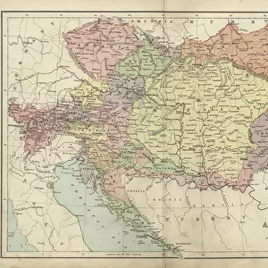
Old Map of Austria 1852 by Henry George Collins

![]()
Wall Art and Photo Gifts from MapSeeker
Old Map of Austria 1852 by Henry George Collins
This is a finely detailed map of Austria remastered from a rare Atlas of the World published in 1852 by Henry George Collins. Although these Henry Collins produced maps of the highest quality in his time unfortunately not the same could be said in terms of his business success. His maps were later obtained by the famous Stanford Map Company and used in their publications
Welcome to the Mapseeker Image library and enter an historic gateway to one of the largest on-line collections of Historic Maps, Nostalgic Views, Vista's and Panorama's from a World gone by.
Media ID 20347239
© Mapseeker Publishing Ltd
Collins Collins Atlas Collins Atlas Map Collins Map
FEATURES IN THESE COLLECTIONS
> Arts
> Photorealistic artworks
> Detailed art pieces
> Masterful detailing in art
> Europe
> Austria
> Related Images
> Maps and Charts
> Related Images
> Maps and Charts
> World
EDITORS COMMENTS
This beautifully preserved print showcases an Old Map of Austria from 1852, meticulously crafted by the talented cartographer Henry George Collins. Remastered from a rare Atlas of the World published in the same year, this map offers a fascinating glimpse into Austria's rich historical landscape. Henry Collins was renowned for his exceptional attention to detail and dedication to producing maps of the highest quality. However, despite his remarkable craftsmanship, he faced challenges when it came to achieving business success. Fortunately, his valuable maps found their way into the hands of the esteemed Stanford Map Company, who recognized their significance and incorporated them into their own publications. The map itself is a testament to Collins' expertise and passion for cartography. Every contour line, river bend, and mountain range is intricately depicted with precision and accuracy. It serves as a window to Austria's past - showcasing its diverse regions, cities, towns, and landmarks as they existed over 150 years ago. As we explore this old Austrian map through our modern lens, we are transported back in time - tracing ancient trade routes that once connected bustling marketplaces or discovering forgotten castles nestled within picturesque landscapes. This piece not only captures historical geography but also invites us to reflect on how much has changed since its creation. Whether you are an avid historian or simply appreciate fine artistry, this Old Map of Austria by Henry George Collins is sure to captivate your imagination while providing invaluable insights into Austria's past.
MADE IN THE USA
Safe Shipping with 30 Day Money Back Guarantee
FREE PERSONALISATION*
We are proud to offer a range of customisation features including Personalised Captions, Color Filters and Picture Zoom Tools
SECURE PAYMENTS
We happily accept a wide range of payment options so you can pay for the things you need in the way that is most convenient for you
* Options may vary by product and licensing agreement. Zoomed Pictures can be adjusted in the Cart.