Home > Arts > Artists > B > Joan Blaeu
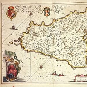
The Isle of Anglesey, The Isle of Man and the Isle of Wight, 1650, (1946). Creator: Unknown
. Creator: Unknown")
![]()
Wall Art and Photo Gifts from Heritage Images
The Isle of Anglesey, The Isle of Man and the Isle of Wight, 1650, (1946). Creator: Unknown
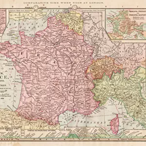
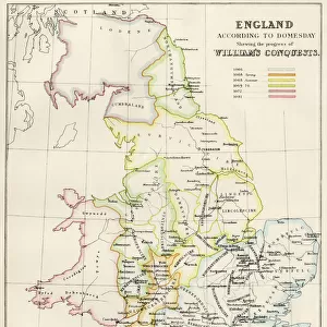
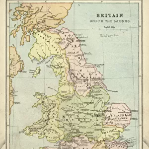
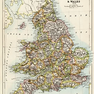
The Isle of Anglesey, The Isle of Man and the Isle of Wight, 1650, (1946). Three maps of islands off the coast of Britain. After illustrations in Joan Blaeus " Theatrum Orbis Terrarum Sive Atlas Novus", published in the 1640s. From " Islands Round Britain", by R. M. Lockley. [Collins, London, 1946]
Heritage Images features heritage image collections
Media ID 19777296
© The Print Collector/Heritage Images
Blaeu Britain In Pictures Cartography Coastline Collins Island Islands Isle Of Man Isle Of Wight Joan Joan Blaeu Johann Blaeu Johannes Blaeu Lockley Map Making Mapmaking R M Lockley Ronald Ronald Lockley Ronald Mathias Ronald Mathias Lockley Social History Wales William Collins William Collins And Sons William Collins Sons Isle Of Anglesey
FEATURES IN THESE COLLECTIONS
> Animals
> Mammals
> Muridae
> Fortior
> Arts
> Artists
> B
> Joan Blaeu
> Arts
> Artists
> C
> William Collins
> Europe
> United Kingdom
> England
> Maps
> Europe
> United Kingdom
> Wales
> Anglesey
> Related Images
> Europe
> United Kingdom
> Wales
> Maps
> Europe
> United Kingdom
> Wales
> Posters
> Maps and Charts
> Related Images
> Maps and Charts
> Wales
EDITORS COMMENTS
This print showcases three maps of the stunning islands off the coast of Britain: The Isle of Anglesey, The Isle of Man, and The Isle of Wight. Created in 1650 but published in 1946 as part of "Islands Round Britain" by R. M. Lockley, these maps were inspired by illustrations found in Joan Blaeus' renowned work "Theatrum Orbis Terrarum Sive Atlas Novus". The vibrant colors and intricate details bring to life the rich history and cartography expertise prevalent during the 17th century. Each island is meticulously depicted with its unique features, coastlines, and landmarks. As we delve into this visual treasure trove, we are transported back in time to an era where mapmaking was a true art form. This print not only serves as a testament to the skillful craftsmanship employed by unknown creators but also offers us a glimpse into how these islands appeared centuries ago. With its historical significance and cultural value, this print provides an invaluable resource for those interested in British social history or anyone seeking to explore the beauty that lies within these enchanting islands. It stands as a reminder that even though time may pass and landscapes may change, our connection to our past remains steadfast through such remarkable pieces of art.
MADE IN THE USA
Safe Shipping with 30 Day Money Back Guarantee
FREE PERSONALISATION*
We are proud to offer a range of customisation features including Personalised Captions, Color Filters and Picture Zoom Tools
SECURE PAYMENTS
We happily accept a wide range of payment options so you can pay for the things you need in the way that is most convenient for you
* Options may vary by product and licensing agreement. Zoomed Pictures can be adjusted in the Cart.