Home > Aerial Photography > Related Images
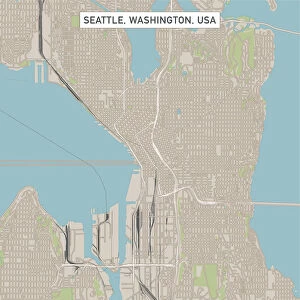
Santa Clarita California US City Street Map

![]()
Wall Art and Photo Gifts from Fine Art Storehouse
Santa Clarita California US City Street Map
Vector Illustration of a City Street Map of Santa Clarita, California, USA. Scale 1:60, 000.
All source data is in the public domain.
U.S. Geological Survey, US Topo
Used Layers:
USGS The National Map: National Hydrography Dataset (NHD)
USGS The National Map: National Transportation Dataset (NTD)
Unleash your creativity and transform your space into a visual masterpiece!
Frank Ramspott
Media ID 15054935
© Frank Ramspott, all rights reserved
Aerial View California City Map Computer Graphic Directly Above Downtown District Gray Road Map Text Digitally Generated Image Green Color White Color
FEATURES IN THESE COLLECTIONS
> Aerial Photography
> Related Images
> Animals
> Insects
> Hemiptera
> Green Scale
> Animals
> Mammals
> Cricetidae
> California Mouse
> Arts
> Contemporary art
> Digital artwork
> Street art
> Arts
> Landscape paintings
> Waterfall and river artworks
> River artworks
> Arts
> Portraits
> Pop art gallery
> Street art portraits
> Arts
> Street art graffiti
> Digital art
> Digital paintings
> Arts
> Street art graffiti
> Digital art
> Vector illustrations
> Fine Art Storehouse
> Map
> Street Maps
> Fine Art Storehouse
> Map
> USA Maps
> Maps and Charts
> Geological Map
> Maps and Charts
> Related Images
EDITORS COMMENTS
This print showcases a meticulously detailed city street map of Santa Clarita, California, USA. Created with precision and artistry, this vector illustration offers a comprehensive view of the bustling downtown district, adorned with the meandering Santa Clara River and nearby lake. The scale of 1:60,000 ensures that every intricate detail is captured flawlessly. The source data for this masterpiece is derived from the public domain, specifically from the U. S. Geological Survey's National Hydrography Dataset (NHD) and National Transportation Dataset (NTD). These reliable sources guarantee accuracy and authenticity in depicting the city's roads and hydrographic features. Rendered in vibrant colors such as gray, green, blue, and white, this digitally generated image provides an aerial view directly above Santa Clarita. With no people present in the scene, viewers can focus solely on admiring the beauty of this cartographic marvel. Designed by Frank Ramspott exclusively for Fine Art Storehouse, this print exemplifies his expertise in creating visually stunning maps that seamlessly blend artistry with scientific precision. Whether you are a resident or visitor to Santa Clarita or simply appreciate exceptional cartography as an art form itself - this print will undoubtedly captivate your imagination.
MADE IN THE USA
Safe Shipping with 30 Day Money Back Guarantee
FREE PERSONALISATION*
We are proud to offer a range of customisation features including Personalised Captions, Color Filters and Picture Zoom Tools
SECURE PAYMENTS
We happily accept a wide range of payment options so you can pay for the things you need in the way that is most convenient for you
* Options may vary by product and licensing agreement. Zoomed Pictures can be adjusted in the Cart.