Home > Aerial Photography > Related Images
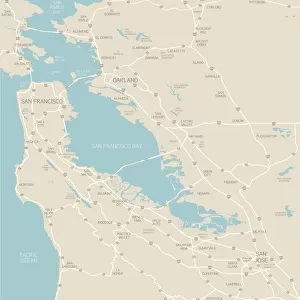
Oakland California US City Street Map

![]()
Wall Art and Photo Gifts from Fine Art Storehouse
Oakland California US City Street Map
Vector Illustration of a City Street Map of Oakland, California, USA. Scale 1:60, 000.
All source data is in the public domain.
U.S. Geological Survey, US Topo
Used Layers:
USGS The National Map: National Hydrography Dataset (NHD)
USGS The National Map: National Transportation Dataset (NTD)
Unleash your creativity and transform your space into a visual masterpiece!
Frank Ramspott
Media ID 15055157
© Frank Ramspott, all rights reserved
Aerial View California City Map Computer Graphic Directly Above Downtown District Gray Pacific Ocean Road Map Text Alameda Digitally Generated Image Green Color Oakland White Color
FEATURES IN THESE COLLECTIONS
> Aerial Photography
> Related Images
> Animals
> Insects
> Hemiptera
> Green Scale
> Animals
> Mammals
> Cricetidae
> California Mouse
> Arts
> Artists
> O
> Oceanic Oceanic
> Arts
> Contemporary art
> Digital artwork
> Street art
> Arts
> Landscape paintings
> Waterfall and river artworks
> River artworks
> Arts
> Portraits
> Pop art gallery
> Street art portraits
> Arts
> Street art graffiti
> Digital art
> Digital paintings
> Arts
> Street art graffiti
> Digital art
> Vector illustrations
> Fine Art Storehouse
> Map
> Street Maps
> Fine Art Storehouse
> Map
> USA Maps
> Maps and Charts
> Geological Map
EDITORS COMMENTS
This print showcases a meticulously detailed vector illustration of the vibrant city streets of Oakland, California, USA. With a scale of 1:60,000, every nook and cranny is beautifully depicted in this artwork. The artist, Frank Ramspott, has skillfully utilized various layers from publicly available data sources such as USGS The National Map: National Hydrography Dataset (NHD) and USGS The National Map: National Transportation Dataset (NTD) to create this visually stunning piece. The image encompasses the downtown district of Oakland along with notable landmarks like Alameda and San Leandro Bay. From the Pacific Ocean to rivers and lakes, all elements are accurately represented on this street map. The intricate network of roads weaves through the cityscape creating an intricate tapestry that captures the essence of Oakland's urban landscape. Rendered in shades of gray, green, blue, and white colors against a texturized background gives it a unique aesthetic appeal. This digitally generated aerial view provides viewers with a bird's-eye perspective directly above the city streets. As there are no people visible in this composition, it emphasizes solely on the physical geography and cartography aspect. Whether you're an avid traveler or simply appreciate fine artistry fused with technology-driven design techniques - this print is sure to captivate your imagination while offering an intriguing glimpse into Oakland's dynamic urban environment.
MADE IN THE USA
Safe Shipping with 30 Day Money Back Guarantee
FREE PERSONALISATION*
We are proud to offer a range of customisation features including Personalised Captions, Color Filters and Picture Zoom Tools
SECURE PAYMENTS
We happily accept a wide range of payment options so you can pay for the things you need in the way that is most convenient for you
* Options may vary by product and licensing agreement. Zoomed Pictures can be adjusted in the Cart.