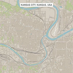
Home > North America > United States of America > Kansas > Kansas City
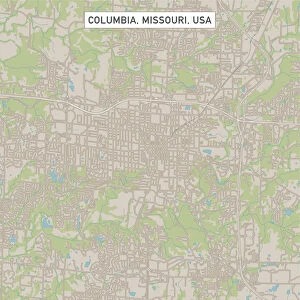
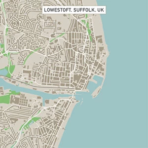
Lawrence Kansas US City Street Map

![]()
Wall Art and Photo Gifts from Fine Art Storehouse
Lawrence Kansas US City Street Map
Vector Illustration of a City Street Map of Lawrence, Kansas, USA. Scale 1:60, 000.
All source data is in the public domain.
U.S. Geological Survey, US Topo
Used Layers:
USGS The National Map: National Hydrography Dataset (NHD)
USGS The National Map: National Transportation Dataset (NTD)
Unleash your creativity and transform your space into a visual masterpiece!
Frank Ramspott
Media ID 15215786
© Frank Ramspott, all rights reserved
Aerial View City Map Computer Graphic Directly Above Downtown District Gray Kansas Lawrence Road Map Text Digitally Generated Image Green Color White Color
FEATURES IN THESE COLLECTIONS
> Aerial Photography
> Related Images
> Animals
> Insects
> Hemiptera
> Green Scale
> Arts
> Contemporary art
> Digital artwork
> Street art
> Arts
> Landscape paintings
> Waterfall and river artworks
> River artworks
> Arts
> Portraits
> Pop art gallery
> Street art portraits
> Arts
> Street art graffiti
> Digital art
> Digital paintings
> Arts
> Street art graffiti
> Digital art
> Vector illustrations
> Fine Art Storehouse
> Map
> Street Maps
> Fine Art Storehouse
> Map
> USA Maps
> Maps and Charts
> Geological Map
> Maps and Charts
> Related Images
> North America
> United States of America
> Kansas
> Kansas City
EDITORS COMMENTS
This print showcases a detailed and meticulously crafted city street map of Lawrence, Kansas, USA. With a scale of 1:60,000, this vector illustration offers an immersive experience into the heart of this vibrant city. The artist, Frank Ramspott, has skillfully utilized various layers from publicly available data sources such as the U. S. Geological Survey's National Hydrography Dataset (NHD) and National Transportation Dataset (NTD), ensuring accuracy and authenticity in every aspect. The image captures the essence of Lawrence with its downtown district highlighted prominently alongside the serene beauty of nearby lakes and rivers. From bustling streets to intricate road networks, every element is intricately designed to provide a comprehensive overview of this charming town. Rendered in striking colors including shades of gray, blue, white, and green; this digitally generated artwork exudes a sense of liveliness despite its absence of people. Its aerial perspective allows viewers to appreciate the physical geography while offering an unparalleled bird's-eye view directly above Lawrence. Perfect for enthusiasts interested in cartography or those seeking unique home decor options that celebrate their love for travel and exploration; this visually stunning piece by Frank Ramspott will undoubtedly add character to any space it adorns.
MADE IN THE USA
Safe Shipping with 30 Day Money Back Guarantee
FREE PERSONALISATION*
We are proud to offer a range of customisation features including Personalised Captions, Color Filters and Picture Zoom Tools
SECURE PAYMENTS
We happily accept a wide range of payment options so you can pay for the things you need in the way that is most convenient for you
* Options may vary by product and licensing agreement. Zoomed Pictures can be adjusted in the Cart.