Home > Maps and Charts > Abraham Ortelius
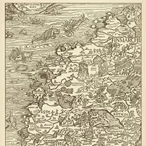
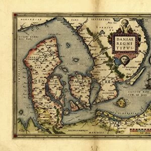
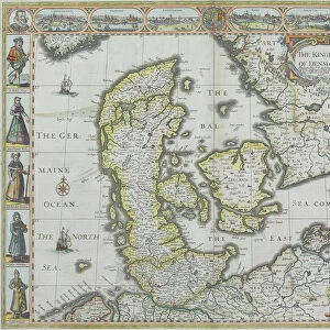
Map of Denmark, from Theatrum Orbis Terrarum by Abraham Ortelius, 1528-1598, Antwerp, 1570

![]()
Wall Art and Photo Gifts from Universal Images Group (UIG)
Map of Denmark, from Theatrum Orbis Terrarum by Abraham Ortelius, 1528-1598, Antwerp, 1570
Cartography, 16th century. Map of Denmark, from Theatrum Orbis Terrarum by Abraham Ortelius (1528-1598), Antwerp, 1570
Universal Images Group (UIG) manages distribution for many leading specialist agencies worldwide
Media ID 9501963
© DEA / A. DAGLI ORTI
16th Century Denmark Latin Script Manuscript Sailing Boat
FEATURES IN THESE COLLECTIONS
> Maps and Charts
> Abraham Ortelius
> Universal Images Group (UIG)
> Art
> Painting, Sculpture & Prints
> Cartography
EDITORS COMMENTS
This print showcases a remarkable piece of cartographic history - the Map of Denmark from Theatrum Orbis Terrarum by Abraham Ortelius. Created in Antwerp, Belgium in 1570, this map is a true testament to the skill and artistry of 16th-century cartographers. The intricate details and precision displayed on this map are awe-inspiring. Every contour of Denmark's physical geography is meticulously depicted, allowing viewers to immerse themselves in the country's diverse landscapes. From its rolling hills to its majestic coastlines, this map offers a glimpse into Denmark's natural beauty. As we delve deeper into the image, our eyes are drawn towards a sailing boat gracefully navigating through the sea surrounding Denmark. This subtle addition not only adds an element of movement but also serves as a reminder of Denmark's rich maritime history. The Latin script inscribed on the map further enhances its historical significance. It transports us back to an era when maps were not just navigational tools but also works of art that celebrated exploration and discovery. With no people present in this image, it allows us to focus solely on the exquisite craftsmanship and attention to detail that went into creating this masterpiece. Its horizontal composition makes it perfect for display purposes, adding elegance and sophistication to any space. This print from Universal Images Group (UIG) is more than just an illustration; it is a gateway into both Danish history and the world of cartography during the Renaissance period.
MADE IN THE USA
Safe Shipping with 30 Day Money Back Guarantee
FREE PERSONALISATION*
We are proud to offer a range of customisation features including Personalised Captions, Color Filters and Picture Zoom Tools
SECURE PAYMENTS
We happily accept a wide range of payment options so you can pay for the things you need in the way that is most convenient for you
* Options may vary by product and licensing agreement. Zoomed Pictures can be adjusted in the Cart.