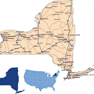
Home > North America > United States of America > New York > New York > Maps
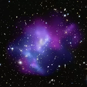
Stereoscopic view of North America

![]()
Wall Art and Photo Gifts from Stocktrek
Stereoscopic view of North America
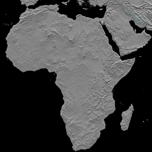
February 2000 - This anaglyph (stereoscopic view) of North America was generated with data from the Shuttle Radar Topography Mission (SRTM). The variety of landforms comprising the North American continent is readily apparent.
Active tectonics (structural deformation of the Earths crust) along and near the Pacific North American plate boundary creates the great topographic relief seen along the Pacific coast. Earths crustal plates converge in southern Mexico and in the northwest United States, melting the crust and producing volcanic cones. Along the California coast, the plates are sliding laterally past each other, producing a pattern of slices within the San Andreas fault system. And, where the plates are diverging, the crust appears torn apart as one huge tear along the Gulf of California (northwest Mexico), and as the several fractures comprising the Basin and Range province (in and around Nevada).
Across the Great Plains, erosional patterns dominate, with stream channels surrounding and penetrating the remnants of older smooth slopes east of the Rocky Mountains. This same erosion process is exposing the bedrock structural patterns of the Black Hills in South Dakota and the Ozark Mountains in Arkansas. Lateral erosion and sediment deposition by the Mississippi River has produced the flatlands of the lower Mississippi Valley and the Mississippi Delta.
To the north, evidence of the glaciers of the last ice age is widely found, particularly east of the Canadian Rocky Mountains and around the Great Lakes. From northeastern British Columbia, across Alberta, Saskatchewan, and Manitoba to North Dakota and Minnesota, huge striations clearly show the flow pattern of the glaciers. And southwest of Lakes Michigan, Huron, and Erie, arcing ridges of sediment, called terminal moraines, show where glaciers dumped sediment at their melting ends.
In eastern Canada, New York, and New England, the terrain has been scoured by glaciers, and eroded by streams, particularly along fractures in the bedrock. In Labrador and Quebec, the Mistastin, Manicougan, and Clearwater Lakes meteor impact craters can also be seen. Further south, narrow curving ridges of upturned and eroded layered rocks form most of the Appalachian Mountains. In contrast, around the Caribbean Sea region (Yucatan, Florida, and the Bahamas), flat-lying, stable limestone platforms are common, while the most eastern islands of the Caribbean include active volcanoes along another convergence zone of tectonic plates
Stocktrek Images specializes in Astronomy, Dinosaurs, Medical, Military Forces, Ocean Life, & Sci-Fi
Media ID 13013313
© Stocktrek Images
America Atlantic Caribbean Sea Coast Coastline Continent Crust Earth Science Elevated Elevation Fault Geography Geology Geoscience Gray Land Feature Landform Mountain Mountainous North America Outline Pacific Pacific Ocean Relief Map Rocky Mountains Tectonics Terrain Territory Texture Topography United States Anaglyph Stereoscopic View From Space
FEATURES IN THESE COLLECTIONS
> Europe
> United Kingdom
> England
> Lakes
> Europe
> United Kingdom
> England
> Maps
> Europe
> United Kingdom
> England
> Rivers
> Europe
> United Kingdom
> England
> York
> North America
> The Bahamas
> Maps
> North America
> Canada
> Lakes
> Related Images
> North America
> Canada
> Maps
> North America
> Mexico
> Lakes
> Related Images
> North America
> United States of America
> Florida
> Clearwater
> North America
> United States of America
> New York
> New York
> Maps
MADE IN THE USA
Safe Shipping with 30 Day Money Back Guarantee
FREE PERSONALISATION*
We are proud to offer a range of customisation features including Personalised Captions, Color Filters and Picture Zoom Tools
SECURE PAYMENTS
We happily accept a wide range of payment options so you can pay for the things you need in the way that is most convenient for you
* Options may vary by product and licensing agreement. Zoomed Pictures can be adjusted in the Cart.