Global temperatures, April 2003

![]()
Wall Art and Photo Gifts from Science Photo Library
Global temperatures, April 2003
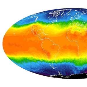
Global temperatures, April 2003. Infrared satellite map of worldwide surface and cloud temperatures in April 2003. The colour-coded map shows temperatures in degrees Celsius, ranging from 40 degrees Celsius (dark red) down to minus 40 degrees Celsius (purple). Features seen here include the deserts of North Africa, warm tropical waters, cold equatorial clouds (yellow band), cloudy temperate regions, and cold polar regions. The data was obtained by the AIRS (Atmospheric Infrared Sounder) instrument as part of the EOS (Earth Observing System) mission, on NASAs Aqua satellite
Science Photo Library features Science and Medical images including photos and illustrations
Media ID 6300059
© NASA/JPL/SCIENCE PHOTO LIBRARY
2003 April Aqua Atmosphere Climate Change Climatological Climatology Cloud Clouds Cold Continent Continental Continents Cool Desert Deserts Earth Observing System Earth Science Environmental Environmental Science Equatorial Freezing From Space Frozen Global Global Warming Infra Red Land Latitude Meteorological Meteorology Planetary Polar Sahara Satellite Satellite Image Seas Spring Temperate Thermogram Thermography Tropic Tropics Warm Weather World Wide Airs Latitudes
EDITORS COMMENTS
This photo print, titled "Global temperatures, April 2003" offers a mesmerizing glimpse into our planet's climate patterns. Captured by the AIRS instrument aboard NASA's Aqua satellite as part of the EOS mission, this infrared satellite map showcases worldwide surface and cloud temperatures during that specific month. The color-coded map beautifully illustrates temperature variations in degrees Celsius, ranging from scorching 40 degrees Celsius (depicted in dark red) to bone-chilling minus 40 degrees Celsius (represented by purple hues). The image unveils several remarkable features such as the vast deserts of North Africa, warm tropical waters, a striking yellow band indicating cold equatorial clouds, cloudy temperate regions, and frigid polar areas. Through this visual representation of Earth's climatic conditions in April 2003, we gain valuable insights into our planet's diverse environments. From frozen polar landscapes to arid desert expanses and vibrant tropical zones – each region plays an integral role in shaping global weather systems. As we contemplate this extraordinary photograph taken from space using advanced technology like atmospheric infrared sounders and satellites equipped with thermal imaging capabilities, it serves as a reminder of the importance of understanding our ever-changing climate. This image not only highlights the beauty and complexity of Earth but also underscores the urgency to address pressing issues such as global warming and climate change for a sustainable future.
MADE IN THE USA
Safe Shipping with 30 Day Money Back Guarantee
FREE PERSONALISATION*
We are proud to offer a range of customisation features including Personalised Captions, Color Filters and Picture Zoom Tools
SECURE PAYMENTS
We happily accept a wide range of payment options so you can pay for the things you need in the way that is most convenient for you
* Options may vary by product and licensing agreement. Zoomed Pictures can be adjusted in the Cart.