Home > Maps and Charts > Germany
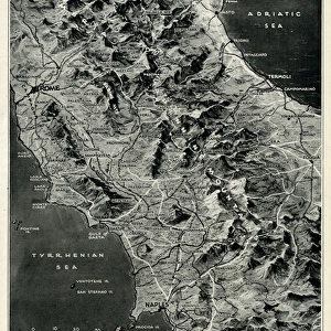
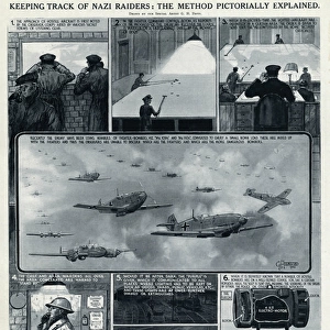
Wartime map of Berlin by G. H. Davis

![]()
Wall Art and Photo Gifts from Mary Evans Picture Library
Wartime map of Berlin by G. H. Davis
A map of Berlin during the Second World War, explaining why the German capital city is the focus of RAF bombing, showing the main war industries, transport centres and power stations. Date: 1943
Mary Evans Picture Library makes available wonderful images created for people to enjoy over the centuries
Media ID 14132347
© Illustrated London News Ltd/Mary Evans
1943 Allied Allies Areas Berlin Bombing Capital Centres Davis Districts Focus Industries Main Power Stations
FEATURES IN THESE COLLECTIONS
> Maps and Charts
> Early Maps
> Maps and Charts
> World
EDITORS COMMENTS
This evocative wartime map of Berlin, created by renowned cartographer G.H. Davis in 1943, offers a striking insight into the strategic importance of the German capital city during World War II. At the heart of the Axis Powers' war effort, Berlin was a major target for Allied bombing raids, particularly by the Royal Air Force (RAF). The map illustrates the city's key industrial areas, transport centres, and power stations, which were the primary focus of these relentless attacks. The map reveals the extensive damage inflicted upon Berlin's infrastructure, with the darkened areas representing the districts and sectors that had been heavily bombed. The main war industries, such as aircraft manufacturing, armaments production, and synthetic fuel plants, are clearly marked, making it evident why these areas were prioritized targets for the Allies. Transport centres, including railways, roads, and canals, are also highlighted, as they were crucial for the movement of troops and supplies. The power stations, which provided electricity to the city and its industries, were also essential targets, as their destruction would significantly hinder the German war machine. This map offers a poignant reminder of the devastating impact of war on urban areas and the lives of their inhabitants. The map's intricate detail and historical significance make it an invaluable resource for scholars, historians, and anyone interested in the history of World War II and the strategic bombing campaigns of the Allies.
MADE IN THE USA
Safe Shipping with 30 Day Money Back Guarantee
FREE PERSONALISATION*
We are proud to offer a range of customisation features including Personalised Captions, Color Filters and Picture Zoom Tools
SECURE PAYMENTS
We happily accept a wide range of payment options so you can pay for the things you need in the way that is most convenient for you
* Options may vary by product and licensing agreement. Zoomed Pictures can be adjusted in the Cart.