Home > Europe > Italy > Sicily > Messina
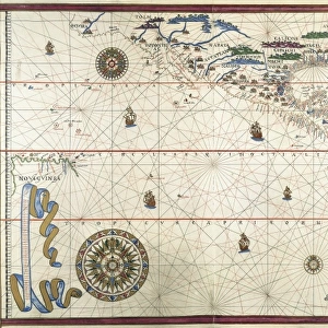
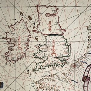
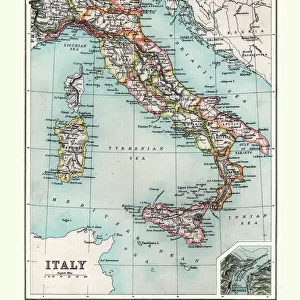
Portolan chart, 1582. Map of the central part

![]()
Wall Art and Photo Gifts from Mary Evans Picture Library
Portolan chart, 1582. Map of the central part
Portolan chart, 1582. Map of the central part of the Mediterranean sea. Printed in Messina. Renaissance art. Miniature Painting
Mary Evans Picture Library makes available wonderful images created for people to enjoy over the centuries
Media ID 8282571
© Mary Evans Picture Library 2015 - https://copyrighthub.org/s0/hub1/creation/maryevans/MaryEvansPictureID/10681992
Chart Cities Compass Geographic Geographical Illuminated Italia Italians Manuscript Manuscripts Mediterranean Messina Miniatures Peninsula Portolan Renaissance
FEATURES IN THESE COLLECTIONS
> Arts
> Art Movements
> Renaissance Art
> Europe
> Italy
> Related Images
> Europe
> Italy
> Sicily
> Messina
> Historic
> Renaissance art
> Italian Renaissance art
EDITORS COMMENTS
This exquisite print, dating back to 1582, showcases a captivating Portolan chart, focusing on the central part of the Mediterranean Sea. The map, produced in Messina, Italy, is a prime example of the Renaissance period's artistic and geographical advancements. The intricately detailed chart illustrates the Italian peninsula, various cities, and islands scattered throughout the Mediterranean. The urban landscapes are depicted with a sense of realism, showcasing the architectural beauty and vibrancy of each city. The geographical features are rendered with precision, making this chart an essential tool for mariners of the time. The map is adorned with an illuminated compass rose, adding an artistic touch to the functional chart. The use of miniature painting techniques adds depth and dimension to the map, making it a work of art in its own right. The rich colors and fine lines create a visual feast for the eyes, transporting us back to the bustling ports and vibrant cities of the Mediterranean during the Renaissance period. Despite its age, this Portolan chart remains an impressive testament to the Italians' mastery of cartography and their commitment to the pursuit of knowledge during the Renaissance era. The intricate details and artistic elements make it a valuable addition to any collection of historical maps or works of art.
MADE IN THE USA
Safe Shipping with 30 Day Money Back Guarantee
FREE PERSONALISATION*
We are proud to offer a range of customisation features including Personalised Captions, Color Filters and Picture Zoom Tools
SECURE PAYMENTS
We happily accept a wide range of payment options so you can pay for the things you need in the way that is most convenient for you
* Options may vary by product and licensing agreement. Zoomed Pictures can be adjusted in the Cart.