Home > South America > Chile > Maps
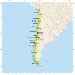
Chile. Santiago de Chile. Map in 1713

![]()
Wall Art and Photo Gifts from Mary Evans Picture Library
Chile. Santiago de Chile. Map in 1713
Chile. Santiago de Chile. Map in 1713 with Mount Santa Lucia, in the background. According to a 1717 engraving
Mary Evans Picture Library makes available wonderful images created for people to enjoy over the centuries
Media ID 14328135
© Thaliastock / Mary Evans
1713 1717 Cartography Chile Continent Founded Geography Lucia Mount Santiago Urbanism Santa
FEATURES IN THESE COLLECTIONS
> Maps and Charts
> Early Maps
> South America
> Chile
> Maps
> South America
> Chile
> Santiago
EDITORS COMMENTS
This map print dates back to the early 18th century, specifically from the years 1713 and 1717, depicting the developing urban landscape of Santiago de Chile. During this period, Santiago was still in its formative years as a city, having been officially founded just a few decades prior in 1541. The map, which is a combination of two separate engravings, provides a unique glimpse into the geography and urbanism of Santiago during the colonial era. The mapocho river, a vital water source for the city, winds its way through the center of the map, dividing the urban area from the rural lands beyond. In the background, the imposing Mount Santa Lucia dominates the skyline, its peak reaching towards the heavens. The map also reveals the early layout of the city, with its grid-like streets and clear delineation of the various neighborhoods and districts. Santiago's growth during this time was driven by the expanding Spanish colonial presence in South America, and the map reflects the European influence on the city's urban planning. This map is an essential historical document, offering valuable insights into the geography, urban development, and colonial history of Santiago de Chile during the early modern period. Its intricate details and beautiful engraving techniques make it a stunning addition to any collection of historical maps or South American studies.
MADE IN THE USA
Safe Shipping with 30 Day Money Back Guarantee
FREE PERSONALISATION*
We are proud to offer a range of customisation features including Personalised Captions, Color Filters and Picture Zoom Tools
SECURE PAYMENTS
We happily accept a wide range of payment options so you can pay for the things you need in the way that is most convenient for you
* Options may vary by product and licensing agreement. Zoomed Pictures can be adjusted in the Cart.