Home > Arts > Artists > H > Jodocus Hondius
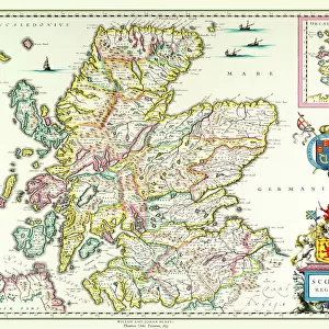
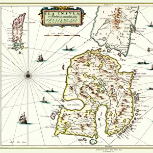
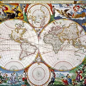
Old Map of the Isle of Islay Scotland 1654 by Johan Blaeu from the Atlas Novus

![]()
Wall Art and Photo Gifts from MapSeeker
Old Map of the Isle of Islay Scotland 1654 by Johan Blaeu from the Atlas Novus
This detailed and most attractive reproduction map of The Isle of Islay has been carefully art worked from a scan of an antique original. The famous firm of Dutch cartographers and publishers was established in the late 16th century by Willem Janszoon Blaeu in Amsterdam. Blaeu was a maker of globes and scientific instruments and purchased some of his early map plates from Jodocus Hondius. From this small beginning was to emerge one of the largest and most prolific map publishing houses of the seventeenth century
Welcome to the Mapseeker Image library and enter an historic gateway to one of the largest on-line collections of Historic Maps, Nostalgic Views, Vista's and Panorama's from a World gone by.
Media ID 20347816
Blaeu Blaeu Family Blaue Map Historic Map Johan Blaeu Johan Blaeu Map Old Blaue Map Isle Of Islay
FEATURES IN THESE COLLECTIONS
> Arts
> Artists
> B
> Willem Blaeu
> Arts
> Artists
> H
> Jodocus Hondius
> Arts
> Photorealistic artworks
> Detailed art pieces
> Masterful detailing in art
> Europe
> United Kingdom
> Scotland
> Maps
> Maps and Charts
> Early Maps
> Maps and Charts
> Related Images
> Maps and Charts
> Willem Janszoon Blaeu
> MapSeeker
> Maps from the British Isles
> Scotland and Counties PORTFOLIO
EDITORS COMMENTS
This beautifully crafted reproduction of the "Old Map of the Isle of Islay Scotland 1654" by Johan Blaeu takes us back in time to explore the rich history and captivating landscapes of this enchanting Scottish island. Carefully art worked from a scan of an antique original, this detailed map showcases the expertise and precision that made Blaeu's cartography renowned. The famous Dutch firm established by Willem Janszoon Blaeu in Amsterdam during the late 16th century was not only a publisher but also a maker of globes and scientific instruments. This small beginning would eventually lead to one of the largest and most prolific map publishing houses of the seventeenth century. As we delve into this historic map, we uncover fascinating insights into Islay's past. From its charming villages to its rugged coastlines, every detail is meticulously depicted, allowing us to envision life on this remote island centuries ago. The intricate illustrations transport us through time as we imagine sailors navigating these waters or locals traversing ancient paths. Whether you are an avid historian or simply captivated by maps, this reproduction offers a glimpse into Islay's heritage that is both educational and visually stunning. Hang it proudly on your wall or use it as a conversation starter; either way, let yourself be transported to another era with this remarkable piece of history captured on paper.
MADE IN THE USA
Safe Shipping with 30 Day Money Back Guarantee
FREE PERSONALISATION*
We are proud to offer a range of customisation features including Personalised Captions, Color Filters and Picture Zoom Tools
SECURE PAYMENTS
We happily accept a wide range of payment options so you can pay for the things you need in the way that is most convenient for you
* Options may vary by product and licensing agreement. Zoomed Pictures can be adjusted in the Cart.