Home > Architecture > Industrial
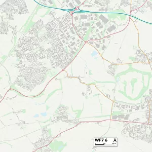
Kirklees WF15 6 Map

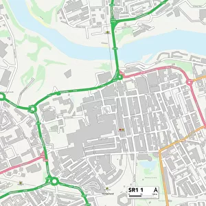
![]()
Wall Art and Photo Gifts from Map Marketing
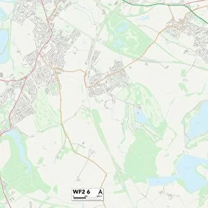
Kirklees WF15 6 Map
Postcode Sector Map of Kirklees WF15 6
Media ID 19980762
A638 Alexandra Street Arnold Street Bank Street Barker Street Bennett Street Boundary Street Bradford Road Carr Street Chapel Street Chiltern Way Church Lane Church Street Churchfield Close Cotswold Drive Dacre Close Darley Road Denby Close Edward Street Elizabeth Street Fair View Fairfield Court Garden Avenue Garden Close Garden Walk George Street Gray Street Green Road Halifax Road Highfield Drive Holme Street Industrial Street Ings Road John William Street Kirklands Kirklees Lee Street Leeds Road Linton Close Middleton Court Primrose Lane Prospect Terrace Quaker Lane Ripley Road South Street Spring Street Springfield Lane Stanley Lane Strawberry Bank Tanhouse Lane The Court Thomas Street Union Road Valley Court Valley Road Vernon Road Vicar Street Wakefield Road Well Street Wharton Street Flush Garden View
FEATURES IN THESE COLLECTIONS
> Arts
> Artists
> B
> George Barker
> Arts
> Artists
> B
> John Barker
> Arts
> Artists
> B
> William Bradford
> Arts
> Artists
> F
> William Edward Frost
> Arts
> Artists
> G
> Thomas Gray
> Arts
> Artists
> H
> John Hillers
> Arts
> Artists
> H
> John Hills
> Arts
> Artists
> H
> Thomas Hill
> Arts
> Artists
> H
> Thomas Holme
> Map Marketing
> Postcode Sector Maps
> WF - Wakefield
MADE IN THE USA
Safe Shipping with 30 Day Money Back Guarantee
FREE PERSONALISATION*
We are proud to offer a range of customisation features including Personalised Captions, Color Filters and Picture Zoom Tools
SECURE PAYMENTS
We happily accept a wide range of payment options so you can pay for the things you need in the way that is most convenient for you
* Options may vary by product and licensing agreement. Zoomed Pictures can be adjusted in the Cart.