Home > Architecture > Industrial
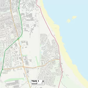
Thurrock RM15 4 Map

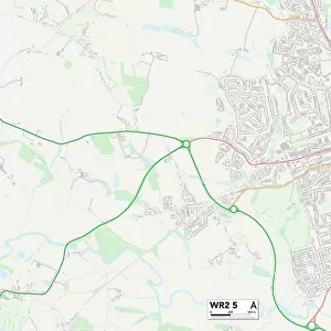
![]()
Wall Art and Photo Gifts from Map Marketing
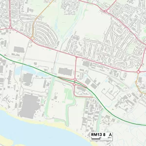
Thurrock RM15 4 Map
Postcode Sector Map of Thurrock RM15 4
Media ID 19979026
Alfred Road Beech Grove Blenheim Gardens Buchanan Close Central Avenue Chichester Close Church View Clare Court Crescent Road Crescent Way Davis Road Eastern Avenue Elm Road Field Road Grange Road Hall Avenue Hall Crescent Hall Road High Street London Road Love Lane Lowlands Road Manor Close Martin Road Meadow Drive Mill Road Myrtle Grove Park Lane Park View Pembroke Drive Perry Way Romford Road Rowan Grove Sandy Lane Severn Road Shannon Way Ship Lane St Michaels Close St Pauls Close St Pauls Place Swale Close Tamar Drive The Rowans Thurrock Usk Road Aveley Hall Terrace
FEATURES IN THESE COLLECTIONS
> Arts
> Artists
> D
> Alfred
> Related Images
> Europe
> United Kingdom
> England
> Kent
> Church Street
> Europe
> United Kingdom
> England
> Kent
> Court-at-Street
> Europe
> United Kingdom
> England
> Kent
> Grange
> Europe
> United Kingdom
> England
> Kent
> Grove
> Europe
> United Kingdom
> England
> Kent
> Halling
> Europe
> United Kingdom
> England
> Kent
> High Street
> Europe
> United Kingdom
> England
> Kent
> Kent Street
> Europe
> United Kingdom
> England
> Kent
> Perry Street
> Map Marketing
> Postcode Sector Maps
> RM - Romford
MADE IN THE USA
Safe Shipping with 30 Day Money Back Guarantee
FREE PERSONALISATION*
We are proud to offer a range of customisation features including Personalised Captions, Color Filters and Picture Zoom Tools
SECURE PAYMENTS
We happily accept a wide range of payment options so you can pay for the things you need in the way that is most convenient for you
* Options may vary by product and licensing agreement. Zoomed Pictures can be adjusted in the Cart.