Home > Europe > United Kingdom > Wales > Ceredigion > Cardigan
Rochdale OL12 6 Map

![]()
Wall Art and Photo Gifts from Map Marketing
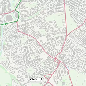
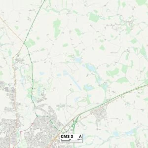
Rochdale OL12 6 Map
Postcode Sector Map of Rochdale OL12 6
Media ID 19976230
Arthur Street Ashworth Street Augusta Close Augusta Street Bentley Street Betony Close Blackthorn Close Burwell Close Cardigan Street Clarence Street Clarkes Lane Clover Street College Road Daffodil Close Dahlia Close Daisy Street Dell Road Eden Street Edmund Street Fenwick Street Forest View Foxglove Court Green Lane Greenhill Avenue Handley Street Harebell Close Holland Street Holmes Road Holmes Street Honeysuckle Way Jane Street Joseph Street Lombard Street Mabel Street Mellor Street Mitchell Street Mount Street New Street Oxford Way Paton Street Pavilion Close Peel Street Primrose Street Rochdale Silver Street The Spinney Tintern Avenue Turnpike Close Windermere Street Woodfield Avenue Woodland Road
FEATURES IN THESE COLLECTIONS
> Animals
> Insects
> Spiders
> Silver Garden
> Arts
> Artists
> A
> Joseph Arthur
> Arts
> Artists
> J
> Jacob Jacobs
> Arts
> Artists
> M
> Arthur Joseph Meadows
> Arts
> Artists
> W
> Joseph Wood
> Arts
> Landscape paintings
> Forest and woodland scenes
> Forest artwork
> Europe
> United Kingdom
> Scotland
> Aberdeenshire
> Aberdeen
> Europe
> United Kingdom
> Wales
> Ceredigion
> Cardigan
> Map Marketing
> Postcode Sector Maps
> OL - Oldham
> Maps and Charts
> Related Images
MADE IN THE USA
Safe Shipping with 30 Day Money Back Guarantee
FREE PERSONALISATION*
We are proud to offer a range of customisation features including Personalised Captions, Color Filters and Picture Zoom Tools
SECURE PAYMENTS
We happily accept a wide range of payment options so you can pay for the things you need in the way that is most convenient for you
* Options may vary by product and licensing agreement. Zoomed Pictures can be adjusted in the Cart.