Home > Europe > United Kingdom > Scotland > Strathclyde > Hamilton
Bury M25 9 Map

![]()
Wall Art and Photo Gifts from Map Marketing
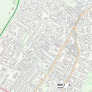
Bury M25 9 Map
Postcode Sector Map of Bury M25 9
Media ID 19975077
Barnhill Road Bolton Close Bury Byron Avenue Chandos Road Chapel Road Crescent Avenue Crosslands Fitzgerald Close George Street Hamilton Close Hamilton Road Hillcrest Road Hilton Drive Hilton Lane Hope Road Links View Lowther Close Lowther Road Masefield Avenue Mayfield Road Myrtle Grove Oak Bank Poplar Drive River View Close Roman Road Ruskin Road Sandy Lane Scott Road Shakespeare Road Shelley Road Shrewsbury Road South Row Spring Vale St Anns Close St Anns Road The Downs Vale Drive Vernon Drive Wensley Road West Row Woodward Road Norwood Ringstone
FEATURES IN THESE COLLECTIONS
> Arts
> Artists
> R
> Roman Roman
> Europe
> United Kingdom
> Scotland
> Strathclyde
> Hamilton
> Map Marketing
> Postcode Sector Maps
> M - Manchester
> Maps and Charts
> Related Images
MADE IN THE USA
Safe Shipping with 30 Day Money Back Guarantee
FREE PERSONALISATION*
We are proud to offer a range of customisation features including Personalised Captions, Color Filters and Picture Zoom Tools
SECURE PAYMENTS
We happily accept a wide range of payment options so you can pay for the things you need in the way that is most convenient for you
* Options may vary by product and licensing agreement. Zoomed Pictures can be adjusted in the Cart.