Home > Europe > United Kingdom > England > Somerset > Lyng
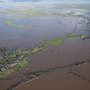
East Lyng flooding 27897_016

![]()
Wall Art and Photo Gifts from Historic England
East Lyng flooding 27897_016
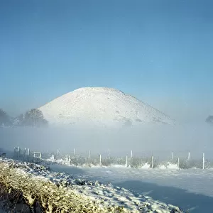
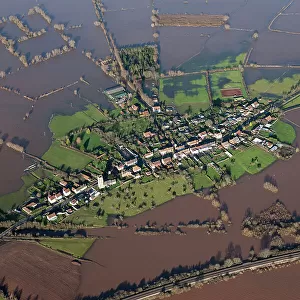
East Lyng, Somerset. At the end of the 9th century AD King Alfred the Great established a burh, or fortified settlement, at the eastern end of the Lyng ridge. The town was linked to the nearby stronghold and monastery at Athelney, founded by Alfred a few years earlier, and all were surrounded by the marshes of the Somerset Levels. This image, taken at the height of the flooding in the winter of 2013/14, shows the logic behind the location of the settlement, now called East Lyng. Digital photograph taken in 2014
Historic England is the public body that champions and protects England's historic places
Media ID 10928639
© Historic England
Archive Picturing England Village
FEATURES IN THESE COLLECTIONS
> Aerial Photography
> England
> Aerial Photography
> Related Images
> Arts
> Artists
> D
> Alfred
> Related Images
> Arts
> Artists
> E
> Alfred East
> Europe
> United Kingdom
> England
> Somerset
> Aller
> Europe
> United Kingdom
> England
> Somerset
> Athelney
> Europe
> United Kingdom
> England
> Somerset
> Lyng
> Europe
> United Kingdom
> England
> Somerset
> Related Images
> Historic England
> More features
> Climate and weather
> Flooding
> Historic England
> Historic Images
> Picturing England
> Historic England
> Seasons
> Seasons: Winter
EDITORS COMMENTS
In this evocative aerial photograph, the historic village of East Lyng in Somerset, England, is submerged in the winter flooding of 2013/14. The image serves as a poignant reminder of the area's rich history and the strategic reasoning behind the settlement's establishment over a thousand years ago. At the end of the 9th century AD, King Alfred the Great, one of England's most renowned monarchs, founded a burh, or fortified settlement, at the eastern end of the Lyng ridge. This defensive structure was part of Alfred's wider efforts to protect his kingdom from Viking invaders. The town was strategically located, not only for its defensive advantages but also for its proximity to the nearby stronghold and monastery at Athelney, which Alfred had established a few years earlier. Both settlements were surrounded by the marshes of the Somerset Levels, providing an additional layer of protection. The flooding in the photograph underscores the importance of this location. The marshy terrain, which once offered protection, now poses a threat, engulfing the village in water. Yet, the image also highlights the resilience of the community, as the village continues to stand, albeit underwater. The historic buildings, some of which date back to the time of King Alfred, remain visible, a testament to their enduring strength. This photograph, taken by Damian Grady from Historic England, offers a unique perspective on the history and geography of East Lyng. It serves as a reminder of the challenges faced by those who lived here in the past and the ongoing efforts to preserve the area's rich heritage. The image is a powerful reminder of the past, present, and future of this historic village.
MADE IN THE USA
Safe Shipping with 30 Day Money Back Guarantee
FREE PERSONALISATION*
We are proud to offer a range of customisation features including Personalised Captions, Color Filters and Picture Zoom Tools
SECURE PAYMENTS
We happily accept a wide range of payment options so you can pay for the things you need in the way that is most convenient for you
* Options may vary by product and licensing agreement. Zoomed Pictures can be adjusted in the Cart.