Home > Europe > United Kingdom > England > London > Transport > Railway
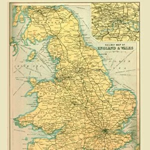
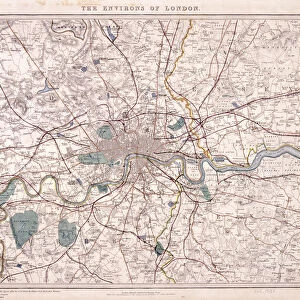
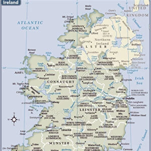
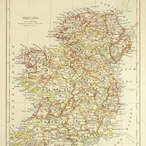
Railway Map of the British Isles, 1902. Creator: Unknown

![]()
Wall Art and Photo Gifts from Heritage Images
Railway Map of the British Isles, 1902. Creator: Unknown
Railway Map of the British Isles, 1902. Showing the railway network across Britain and Ireland. From The Century Atlas of the World. [John Walker & Co, Ltd. London, 1902]
Heritage Images features heritage image collections
Media ID 15512552
© The Print Collector / Heritage-Images
British Isles Edinburgh Geographical Institute Eire Ireland Network
FEATURES IN THESE COLLECTIONS
> Europe
> Republic of Ireland
> Maps
> Europe
> United Kingdom
> England
> London
> Transport
> Railway
> Europe
> United Kingdom
> Scotland
> Edinburgh
> Edinburgh
> Europe
> United Kingdom
> Scotland
> Lothian
> Edinburgh
> Maps and Charts
> Related Images
> Maps and Charts
> World
> Popular Themes
> Railway Posters
EDITORS COMMENTS
This print showcases a meticulously detailed "Railway Map of the British Isles, 1902". Created by an unknown artist, this map offers a fascinating glimpse into the extensive railway network that spanned across Britain and Ireland during the early 20th century. The vibrant colors bring life to the intricate lines and symbols representing various train routes and stations. As we delve into this historical artifact from "The Century Atlas of the World" published by John Walker & Co in London, we are transported back in time to an era when rail travel was at its peak. This map not only serves as a testament to technological advancements but also highlights the importance of transportation infrastructure for connecting communities. The Edinburgh Geographical Institute played a crucial role in producing this masterpiece, ensuring accuracy and precision throughout. From bustling cities like London and Dublin to remote corners of Scotland and Wales, no region is left uncharted on this comprehensive railway map. With Eire (Ireland) included alongside Britain, it reminds us of their shared history intertwined through transport links. Though created over a century ago, this print still holds relevance today as it allows us to appreciate how our modern transportation systems have evolved from these humble beginnings. Preserved by The Print Collector with utmost care, this remarkable piece invites us to explore not just geographical landscapes but also cultural connections fostered by railways. Let's cherish this snapshot from history that continues to inspire awe and curiosity about our past modes of travel.
MADE IN THE USA
Safe Shipping with 30 Day Money Back Guarantee
FREE PERSONALISATION*
We are proud to offer a range of customisation features including Personalised Captions, Color Filters and Picture Zoom Tools
SECURE PAYMENTS
We happily accept a wide range of payment options so you can pay for the things you need in the way that is most convenient for you
* Options may vary by product and licensing agreement. Zoomed Pictures can be adjusted in the Cart.