Home > Europe > United Kingdom > England > London > Towns > Hackney
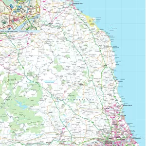
Map of London, 1753

![]()
Wall Art and Photo Gifts from Heritage Images
Map of London, 1753
Map of London, 1753. Map of Westminster, the City of London, Southwark, the River Thames and surrounding areas, with two tables detailing Hackney coach fares and watermens fares
Heritage Images features heritage image collections
Media ID 15175544
© London Metropolitan Archives (City of London) / Heritage-Images
Cartography Map Making Southwark Thames Urbanisation City Of Westminster
FEATURES IN THESE COLLECTIONS
> Arts
> Landscape paintings
> Waterfall and river artworks
> River artworks
> Arts
> Minimalist artwork
> Monochrome artwork
> Monochrome paintings
> Europe
> United Kingdom
> England
> London
> Boroughs
> City of London
> Europe
> United Kingdom
> England
> London
> Boroughs
> City of Westminster
> Europe
> United Kingdom
> England
> London
> Boroughs
> Hackney
> Europe
> United Kingdom
> England
> London
> Boroughs
> Southwark
> Europe
> United Kingdom
> England
> London
> River Thames
> Europe
> United Kingdom
> England
> London
> Towns
> Hackney
> Europe
> United Kingdom
> England
> Maps
> Europe
> United Kingdom
> England
> Rivers
EDITORS COMMENTS
This print showcases a remarkable piece of history - the Map of London, 1753. Created by an anonymous cartographer in the 18th century, this intricate map provides a detailed depiction of Westminster, the City of London, Southwark, and their surrounding areas. It also highlights the majestic River Thames that gracefully winds its way through the heart of this bustling city. The monochrome engraving offers a glimpse into England's past, capturing the essence of urbanization during this era. As you explore this fascinating map, your eyes will be drawn to two tables meticulously detailing Hackney coach fares and watermen's fares - providing valuable insights into transportation costs at that time. Preserved within Guildhall Library and Art Gallery, this British treasure allows us to marvel at the craftsmanship involved in map making centuries ago. Its historical significance lies not only in its accuracy but also in its ability to transport us back to a time when horse-drawn carriages traversed these streets and boats sailed along the mighty Thames. As we gaze upon this snapshot from our nation's capital over two centuries ago, let us appreciate how far we have come while cherishing our rich heritage. This print serves as a reminder that every street corner holds stories untold; it invites us to delve deeper into our country's past and embrace our shared cultural identity.
MADE IN THE USA
Safe Shipping with 30 Day Money Back Guarantee
FREE PERSONALISATION*
We are proud to offer a range of customisation features including Personalised Captions, Color Filters and Picture Zoom Tools
SECURE PAYMENTS
We happily accept a wide range of payment options so you can pay for the things you need in the way that is most convenient for you
* Options may vary by product and licensing agreement. Zoomed Pictures can be adjusted in the Cart.