Home > Europe > United Kingdom > England > London > Transport > Railway
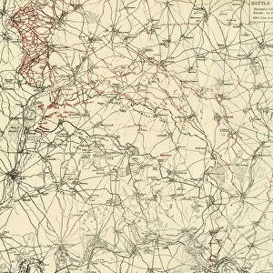
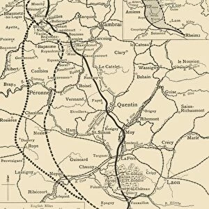
Map To Illustrate the Battle of the Somme, (1919). Creator: George Philip & Son Ltd
. Creator: George Philip & Son Ltd")
![]()
Wall Art and Photo Gifts from Heritage Images
Map To Illustrate the Battle of the Somme, (1919). Creator: George Philip & Son Ltd
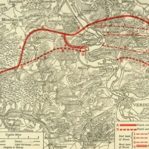
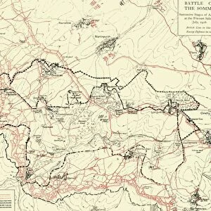
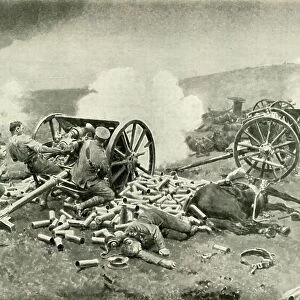
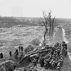
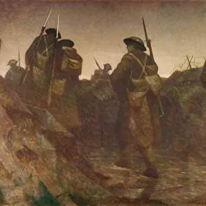
Map To Illustrate the Battle of the Somme, (1919). The First World War Battle of the Somme, fought between the armies of the British Empire and French Third Republic against the German Empire, took place between 1 July and 18 November 1916 on both sides of the River Somme in northern France. Railways, roads and German lines are shown. From " The History of the Great European War: its causes and effects", Vol. VI, by W. Stanley Macbean Knight. [Caxton Pulishing Company, Limited, London, 1919]
Heritage Images features heritage image collections
Media ID 19046961
© The Print Collector/Heritage Images
Albert And Son Ltd Battle Of The Somme Caxton Publishing Company Caxton Pulishing Company Caxton Pulishing Company Lim Caxton Pulishing Company Limited Caxton Pulishing Company Ltd Front Line George Philip And Son George Philip And Son Ltd Knight Limited Philip Picardy Somme Stanley Macbean Stanley Macbean Knight W Stanley Macbean W Stanley Macbean Knight William Stanley Macbean William Stanley Macbean Knight
FEATURES IN THESE COLLECTIONS
> Arts
> Artists
> C
> William Caxton
> Arts
> Artists
> W
> George White
> Arts
> Artists
> W
> William White
> Europe
> France
> Canton
> Somme
> Europe
> United Kingdom
> England
> London
> Transport
> Railway
> Historic
> Battles
> Battle of the Somme
> Historic
> Battles
> Related Images
EDITORS COMMENTS
This print showcases a map titled "Map To Illustrate the Battle of the Somme, (1919)" created by George Philip & Son Ltd. The image provides a detailed depiction of the historic First World War Battle of the Somme, which occurred between 1 July and 18 November 1916 in northern France. The map highlights key elements such as railways, roads, and German lines that played crucial roles during this significant battle fought between the armies of the British Empire and French Third Republic against the German Empire. It offers valuable insights into the strategic planning and movements that took place on both sides of the River Somme. Taken from W. Stanley Macbean Knight's book "The History of the Great European War: its causes and effects" published by Caxton Publishing Company Limited in London in 1919, this print serves as a historical artifact capturing an important moment in time. With its monochrome aesthetic, it evokes a sense of nostalgia for an era marked by conflict but also resilience. This image transports viewers back to one of history's most devastating wars – World War I – reminding us not only of its immense human cost but also highlighting how transportation systems like railways shaped military strategies during this period. Overall, this print is a testament to our collective past and serves as a reminder to learn from history while honoring those who sacrificed their lives on these battlefields.
MADE IN THE USA
Safe Shipping with 30 Day Money Back Guarantee
FREE PERSONALISATION*
We are proud to offer a range of customisation features including Personalised Captions, Color Filters and Picture Zoom Tools
SECURE PAYMENTS
We happily accept a wide range of payment options so you can pay for the things you need in the way that is most convenient for you
* Options may vary by product and licensing agreement. Zoomed Pictures can be adjusted in the Cart.