Home > Africa > Democratic Republic of the Congo > Lakes > Lake Tanganyika
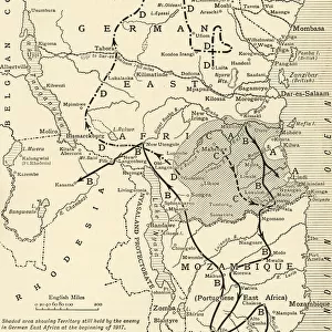
Colonial possessions in East Africa during the First World War, c1916, (c1920). Creator: Unknown
. Creator: Unknown")
![]()
Wall Art and Photo Gifts from Heritage Images
Colonial possessions in East Africa during the First World War, c1916, (c1920). Creator: Unknown
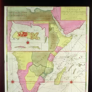
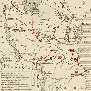
Colonial possessions in East Africa during the First World War, c1916, (c1920). Map showing German East Africa, British East Africa, the Belgian Congo, Rhodesia, Uganda, Nyasaland Protectorate and Mozambique (Portuguese East Africa). Also shown are the various positions of the combatant armies. From " The Great World War: A History", Volume VI, edited by Frank A Mumby. [The Gresham Publishing Company Ltd, London, c1920]
Heritage Images features heritage image collections
Media ID 19665725
© The Print Collector/Heritage Images
Arrows Belgian Congo British Central Africa Protectorate British East Africa British Protectorate Colonies Colony Congo East Africa Frank A Frank A Mumby Frank Arthur Frank Arthur Mumby Front Line Frontline General Jan General Jan Smuts German East Africa Gresham Publishing Co Ltd Gresham Publishing Company Imperialism Jan Christiaan Smuts Kenya Keystone Archives Lake Tanganyika Africa Lake Victoria Lines Mozambique Mumby Mumby Frank A Mumby Frank Arthur Nyasaland Position Positions Rhodesia Rhodesia Africa Smuts The Great World War A History Theatre Of War Uganda Victoria Nyanza Battlefield General Smuts Jan Smuts Lake Tanganyika Mombasa
FEATURES IN THESE COLLECTIONS
> Africa
> Democratic Republic of the Congo
> Lakes
> Lake Tanganyika
> Africa
> Democratic Republic of the Congo
> Lakes
> Related Images
> Africa
> Kenya
> Lakes
> Lake Victoria
> Africa
> Kenya
> Lakes
> Related Images
> Africa
> Kenya
> Related Images
> Africa
> Mozambique
> Lakes
> Related Images
> Africa
> Mozambique
> Maps
> Africa
> Mozambique
> Related Images
EDITORS COMMENTS
This print captures a map titled "Colonial possessions in East Africa during the First World War, c1916" from the book "The Great World War: A History". Created by an unknown artist around 1920, this historical document provides a visual representation of the territorial divisions in East Africa during that tumultuous time. The map showcases various colonial possessions including German East Africa, British East Africa, the Belgian Congo, Rhodesia, Uganda, Nyasaland Protectorate, and Mozambique (Portuguese East Africa). It also highlights the positions of combatant armies involved in this conflict. The intricate arrows depict movement and strategic planning on both sides. With its detailed depiction of geographical features such as lakes Tanganyika and Victoria along with coastal regions like Mombasa in Kenya, this map offers valuable insights into the complexities of colonialism and imperialism prevalent during that era. Notably present is General Jan Christiaan Smuts who played a significant role as Field Marshal on the front lines. As we observe this image today, it serves as a reminder of how boundaries were redrawn and power dynamics shifted during times of war. This photograph not only documents history but also invites us to reflect upon the impact these events had on shaping nations and their relationships within the African continent.
MADE IN THE USA
Safe Shipping with 30 Day Money Back Guarantee
FREE PERSONALISATION*
We are proud to offer a range of customisation features including Personalised Captions, Color Filters and Picture Zoom Tools
SECURE PAYMENTS
We happily accept a wide range of payment options so you can pay for the things you need in the way that is most convenient for you
* Options may vary by product and licensing agreement. Zoomed Pictures can be adjusted in the Cart.