Home > Granger Art on Demand > Maps
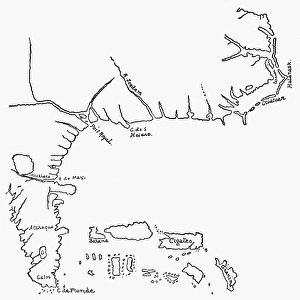
MAP: JOHN WHITE, c1585. Map of Sir Walter Raleighs Virginia (the eastern coast

![]()
Wall Art and Photo Gifts from Granger
MAP: JOHN WHITE, c1585. Map of Sir Walter Raleighs Virginia (the eastern coast
MAP: JOHN WHITE, c1585.
Map of Sir Walter Raleighs Virginia (the eastern coast of North America from Cape Lookout to the Chesapeake Bay). Drawing, c1585, by John White
Granger holds millions of images spanning more than 25,000 years of world history, from before the Stone Age to the dawn of the Space Age
Media ID 12319634
1585 Bradley Smith Cape Chesapeake Bay Coast Colonist Colony East Elizabethan New World Raleigh Southeastern United States Virginia Walter White Lookout
EDITORS COMMENTS
This print showcases a historical treasure, the "MAP: JOHN WHITE, c1585. Map of Sir Walter Raleigh's Virginia". Created by the talented artist John White in 1585 during the Elizabethan era, this drawing provides a glimpse into the early days of colonization in America. The map depicts the eastern coast of North America from Cape Lookout to the Chesapeake Bay, capturing the southeastern region that would later become known as Virginia. It is an invaluable piece for history enthusiasts and those interested in exploring our nation's roots. With intricate details and precise craftsmanship, White's artwork transports us back to a time when brave colonists embarked on their journey to establish new settlements along these shores. The map serves as a testament to Sir Walter Raleigh's vision and ambition for expanding England's influence across the Atlantic. Displayed within this print is not just an image but also a gateway to understanding how exploration shaped our world today. As we admire this Renaissance masterpiece, let us appreciate its significance in documenting early American history and honoring those who paved the way for future generations.
MADE IN THE USA
Safe Shipping with 30 Day Money Back Guarantee
FREE PERSONALISATION*
We are proud to offer a range of customisation features including Personalised Captions, Color Filters and Picture Zoom Tools
SECURE PAYMENTS
We happily accept a wide range of payment options so you can pay for the things you need in the way that is most convenient for you
* Options may vary by product and licensing agreement. Zoomed Pictures can be adjusted in the Cart.