Home > Arts > Landscape paintings > Waterfall and river artworks > Landscape paintings
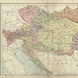
MAP OF EUROPE, 1812-1815. An American map of 1905 comparing the political landscape

![]()
Wall Art and Photo Gifts from Granger
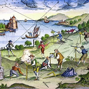
MAP OF EUROPE, 1812-1815. An American map of 1905 comparing the political landscape
MAP OF EUROPE, 1812-1815.
An American map of 1905 comparing the political landscape of Europe before and after the 1815 Congress of Vienna
Granger holds millions of images spanning more than 25,000 years of world history, from before the Stone Age to the dawn of the Space Age
Media ID 12321032
1812 1813 1814 1815 Atlantic Ocean Austria Austro Hungarian Empire Baltic Denmark Galicia Hungary Italy Netherlands North Sea Norway Portugal Prussia Russia Russian Spain Sweden Switzerland Turkey Turkish Congress Of Vienna
FEATURES IN THESE COLLECTIONS
> Arts
> Artists
> O
> Oceanic Oceanic
> Arts
> Landscape paintings
> Waterfall and river artworks
> Landscape paintings
> Asia
> Turkey
> Related Images
> Europe
> Austria
> Related Images
> Granger Art on Demand
> Maps
EDITORS COMMENTS
This print showcases a remarkable American map from 1905, meticulously comparing the political landscape of Europe before and after the historic Congress of Vienna in 1815. The Map of Europe, 1812-1815 takes us on a visual journey through time, shedding light on the significant changes that occurred during this transformative period. With intricate details and vibrant colors, this map highlights the various nations and territories that shaped Europe's destiny. From Russia to Spain, Prussia to Turkey, each country is represented with precision and accuracy. The Atlantic Ocean stretches across the western edge while the Baltic Sea and North Sea border its northern regions. The Congress of Vienna played a pivotal role in reshaping Europe following Napoleon Bonaparte's defeat. This diplomatic gathering aimed to restore stability by redrawing borders and establishing new alliances among European powers. As we compare both sides of this map, it becomes evident how dramatically boundaries shifted as a result of these negotiations. From Austria's expanding influence over Hungary to France losing control over vast territories, every change is captured within this historical snapshot. Galicia emerges as an important region while Italy undergoes significant transformations too. As we delve into this mesmerizing piece of history preserved in print form, let us appreciate not only its artistic beauty but also its ability to transport us back in time. It serves as a reminder that politics have always been instrumental in shaping our world - even two centuries ago when ink met paper to create maps like these.
MADE IN THE USA
Safe Shipping with 30 Day Money Back Guarantee
FREE PERSONALISATION*
We are proud to offer a range of customisation features including Personalised Captions, Color Filters and Picture Zoom Tools
SECURE PAYMENTS
We happily accept a wide range of payment options so you can pay for the things you need in the way that is most convenient for you
* Options may vary by product and licensing agreement. Zoomed Pictures can be adjusted in the Cart.