Home > Arts > Street art graffiti > Digital art > Vector illustrations
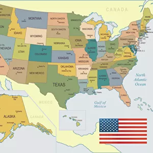
Bend Oregon US City Street Map

![]()
Wall Art and Photo Gifts from Fine Art Storehouse
Bend Oregon US City Street Map
Vector Illustration of a City Street Map of Bend, Oregon, USA. Scale 1:60, 000.
All source data is in the public domain.
U.S. Geological Survey, US Topo
Used Layers:
USGS The National Map: National Hydrography Dataset (NHD)
USGS The National Map: National Transportation Dataset (NTD)
Unleash your creativity and transform your space into a visual masterpiece!
Frank Ramspott
Media ID 15055007
© Frank Ramspott, all rights reserved
Aerial View Bend City Map Computer Graphic Directly Above Downtown District Gray Oregon Road Map Text Deschutes River Digitally Generated Image Green Color White Color
FEATURES IN THESE COLLECTIONS
> Aerial Photography
> Related Images
> Animals
> Insects
> Hemiptera
> Green Scale
> Arts
> Contemporary art
> Digital artwork
> Street art
> Arts
> Landscape paintings
> Waterfall and river artworks
> River artworks
> Arts
> Portraits
> Pop art gallery
> Street art portraits
> Arts
> Street art graffiti
> Digital art
> Digital paintings
> Arts
> Street art graffiti
> Digital art
> Vector illustrations
> Fine Art Storehouse
> Map
> Street Maps
> Fine Art Storehouse
> Map
> USA Maps
> Maps and Charts
> Geological Map
> Maps and Charts
> Related Images
> North America
> United States of America
> Lakes
> Related Images
EDITORS COMMENTS
This print showcases a meticulously detailed city street map of Bend, Oregon, USA. The vector illustration captures the essence of this vibrant city with its diverse features and landmarks. With a scale of 1:60,000, every street and road is intricately depicted, allowing viewers to explore Bend's urban landscape. The source data used in creating this masterpiece is all from the public domain. The U. S. Geological Survey's National Hydrography Dataset (NHD) and National Transportation Dataset (NTD) were utilized as layers to ensure accuracy and authenticity. From the majestic Deschutes River flowing through the heart of the city to its charming downtown district dotted with shops and restaurants, this artwork beautifully encapsulates Bend's unique character. Other notable elements such as lakes, rivers, streets, and roads are also prominently featured on this visually stunning map. Designed using advanced digital technology by Frank Ramspott, this aerial view provides a bird's-eye perspective directly above Bend. The color palette blends shades of gray for text clarity with pops of blue representing water bodies and white for open spaces. Lush green hues symbolize parks and natural areas that make Bend an outdoor enthusiast's paradise. Whether you're a resident or visitor planning your next adventure in Bend or simply appreciate cartography at its finest, this digitally generated image offers an immersive experience into the physical geography of one of America's most picturesque cities.
MADE IN THE USA
Safe Shipping with 30 Day Money Back Guarantee
FREE PERSONALISATION*
We are proud to offer a range of customisation features including Personalised Captions, Color Filters and Picture Zoom Tools
SECURE PAYMENTS
We happily accept a wide range of payment options so you can pay for the things you need in the way that is most convenient for you
* Options may vary by product and licensing agreement. Zoomed Pictures can be adjusted in the Cart.