Home > Arts > Street art graffiti > Digital art > Vector illustrations
Abilene Texas US City Street Map

![]()
Wall Art and Photo Gifts from Fine Art Storehouse
Abilene Texas US City Street Map
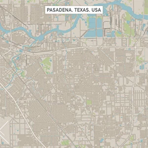
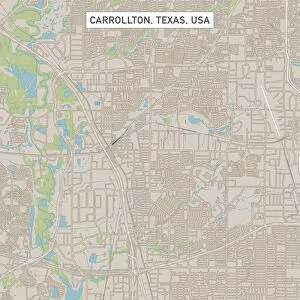
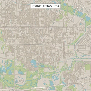
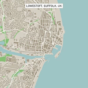
Vector Illustration of a City Street Map of Abilene, Texas, USA. Scale 1:60, 000.
All source data is in the public domain.
U.S. Geological Survey, US Topo
Used Layers:
USGS The National Map: National Hydrography Dataset (NHD)
USGS The National Map: National Transportation Dataset (NTD)
Unleash your creativity and transform your space into a visual masterpiece!
Frank Ramspott
Media ID 15192934
© Frank Ramspott, all rights reserved
Aerial View City Map Computer Graphic Directly Above Downtown District Gray Road Map Texas Text Abilene Digitally Generated Image Green Color White Color
FEATURES IN THESE COLLECTIONS
> Aerial Photography
> Related Images
> Animals
> Insects
> Hemiptera
> Green Scale
> Arts
> Contemporary art
> Digital artwork
> Street art
> Arts
> Landscape paintings
> Waterfall and river artworks
> River artworks
> Arts
> Portraits
> Pop art gallery
> Street art portraits
> Arts
> Street art graffiti
> Digital art
> Digital paintings
> Arts
> Street art graffiti
> Digital art
> Vector illustrations
> Fine Art Storehouse
> Map
> Street Maps
> Fine Art Storehouse
> Map
> USA Maps
> Maps and Charts
> Geological Map
> Maps and Charts
> Related Images
> North America
> United States of America
> Lakes
> Related Images
EDITORS COMMENTS
This print showcases a meticulously detailed city street map of Abilene, Texas, USA. With a scale of 1:60,000, every intricate aspect of the city's layout is beautifully illustrated in this vector image. The source data used to create this masterpiece is all in the public domain and comes from reputable sources such as the U. S. Geological Survey and US Topo. The various layers utilized include the USGS National Hydrography Dataset (NHD) and National Transportation Dataset (NTD), ensuring accuracy and precision in depicting the city's hydrographic features, transportation networks, downtown district, lakes, rivers, streets, roads - essentially everything that makes up Abilene's vibrant urban landscape. Rendered with expert cartography skills and digitally generated imagery by Frank Ramspott, this visually striking artwork offers an aerial view directly above Abilene. The color palette incorporates shades of gray for text elements while blue represents water bodies like lakes and rivers. White signifies roadways while green symbolizes parks or other natural areas within the city. With no people present in the image itself but rather focusing solely on showcasing Abilene's physical geography through computer graphics design techniques; this print is perfect for those who appreciate both artistry and functionality. Whether you're a resident or simply fascinated by maps, this stunning piece will undoubtedly captivate your imagination with its attention to detail and artistic flair
MADE IN THE USA
Safe Shipping with 30 Day Money Back Guarantee
FREE PERSONALISATION*
We are proud to offer a range of customisation features including Personalised Captions, Color Filters and Picture Zoom Tools
SECURE PAYMENTS
We happily accept a wide range of payment options so you can pay for the things you need in the way that is most convenient for you
* Options may vary by product and licensing agreement. Zoomed Pictures can be adjusted in the Cart.