Home > Africa > Related Images
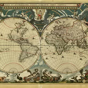
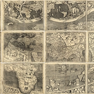
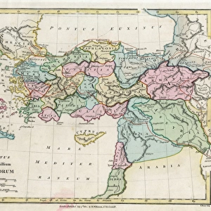
Vintage Map of the World

![]()
Wall Art and Photo Gifts from Fine Art Storehouse
Vintage Map of the World
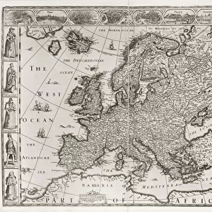
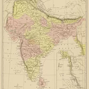
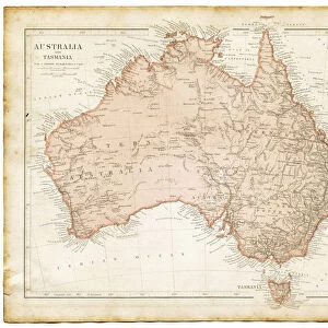
Vintage map of the world from 1837
Unleash your creativity and transform your space into a visual masterpiece!
duncan1890
Media ID 13666637
© duncan1890
1830 1839 1830s Style Asia Pac Atlantic Ocean Australasia Australia Cartographer Chart Discovery Dome Earth East Africa Ephemera Equipment Geographical Locations Globe Globe Navigational Equipment Hemisphere Illustrations And Vector Art Image Created 1830 1839 India Indian Subcontinent Major Ocean Manufactured Object Navigational Equipment North Africa Northern Hemisphere Objects Equipment Oceania Pacific Ocean Past Planet Planet Earth Planet Space Printed Media Retro Revival Southern Africa Southern Hemisphere Sphere The Americas Travel Locations West Africa World Map Image Created 19th Century Retro Styled Victorian Style
FEATURES IN THESE COLLECTIONS
> Africa
> Related Images
> Arts
> Artists
> O
> Oceanic Oceanic
> Asia
> India
> Related Images
> Asia
> Related Images
> Europe
> Related Images
> Fine Art Storehouse
> Map
> Historical Maps
> Maps and Charts
> Early Maps
EDITORS COMMENTS
This vintage map of the world, dating back to 1837, takes us on a journey through time and space. With its intricate details and retro revival charm, it encapsulates the cartography style of the 19th century. Engraved with precision by an anonymous cartographer, this antique image transports us to a bygone era when exploration and discovery were at their peak. The richly illustrated continents - from Europe to Asia, Africa to the Americas - showcase the geographical locations that have shaped our history. As we gaze upon this beautifully preserved piece of ephemera, we are reminded of the ancient wonders that once captivated explorers' imaginations. From India's vibrant subcontinent to Australia's vast landscapes in Australasia, every corner of Earth is represented here. The majesty of our planet unfolds before our eyes as we observe the vast oceans stretching across this globe navigational equipment. The Pacific Ocean merges with the Atlantic Ocean while smaller seas dotting various regions remind us of humanity's reliance on charted waters for navigation. Printed media has come a long way since then but this stunning print serves as a reminder that even in today's digital age, there is still beauty in tangible objects like maps. Duncan1890 has captured not just an image but also a piece of history frozen in time – a testament to mankind's insatiable curiosity about our world and beyond.
MADE IN THE USA
Safe Shipping with 30 Day Money Back Guarantee
FREE PERSONALISATION*
We are proud to offer a range of customisation features including Personalised Captions, Color Filters and Picture Zoom Tools
SECURE PAYMENTS
We happily accept a wide range of payment options so you can pay for the things you need in the way that is most convenient for you
* Options may vary by product and licensing agreement. Zoomed Pictures can be adjusted in the Cart.