Home > Asia > India > Maps
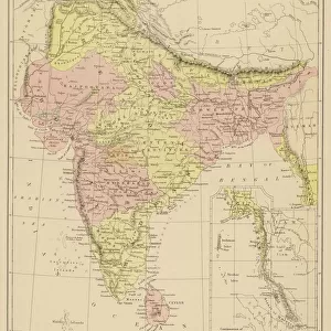
Map of India, 1877 (colour litho)
")
![]()
Wall Art and Photo Gifts from Fine Art Finder
Map of India, 1877 (colour litho)
XCF275016 Map of India, 1877 (colour litho) by English School, (19th century); Private Collection; English, out of copyright
Media ID 12790593
© www.bridgemanimages.com
Bay Of Bengal Bengal British Empire British Raj Burma Cartography Geographical Malay Peninsula Mapping Sumatra
FEATURES IN THESE COLLECTIONS
> Fine Art Finder
> Schools
> English School
> Maps and Charts
> British Empire Maps
> Maps and Charts
> India
EDITORS COMMENTS
This print showcases a beautifully detailed "Map of India, 1877" created by an English School artist in the 19th century. The map is a vibrant colour lithograph that offers a glimpse into the historical cartography and geographical understanding of the time. The intricate details on this map highlight various regions, including the Bay of Bengal, Burma, Sumatra, and the Malay Peninsula. It provides an intriguing visual representation of India's vast landscape during the British Raj era when it was under British imperial rule. Displayed against a neutral background in this photo print, every line and contour stands out vividly. The careful craftsmanship employed to create this piece becomes evident as one explores its features further. With its rich history and cultural significance, this Map of India serves as both an educational tool and a work of art. Its presence evokes curiosity about past explorations and colonial influences on Indian geography. Preserved within a private collection today but made accessible through Fine Art Finder's collaboration with www. bridgemanimages. com, this photograph allows viewers to appreciate not only the beauty but also the historical value embedded within such maps from centuries ago.
MADE IN THE USA
Safe Shipping with 30 Day Money Back Guarantee
FREE PERSONALISATION*
We are proud to offer a range of customisation features including Personalised Captions, Color Filters and Picture Zoom Tools
SECURE PAYMENTS
We happily accept a wide range of payment options so you can pay for the things you need in the way that is most convenient for you
* Options may vary by product and licensing agreement. Zoomed Pictures can be adjusted in the Cart.