Home > Europe > France > Canton > Pas de Calais
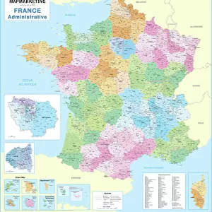
Le Nord (59), Nord Pas De Calais (Nord-Pas-de-Calais) - France and its Colonies. Atlas illustrates one hundred and five maps from the maps of the depot of war, bridges and footwear and the Navy by M. VUILLEMIN. 1876
, Nord Pas De Calais (Nord-Pas-de-Calais) - France and its Colonies. Atlas illustrates one hundred and five maps from the maps of the depot of war, bridges and footwear and the Navy by M. VUILLEMIN. 1876")
![]()
Wall Art and Photo Gifts from Fine Art Finder
Le Nord (59), Nord Pas De Calais (Nord-Pas-de-Calais) - France and its Colonies. Atlas illustrates one hundred and five maps from the maps of the depot of war, bridges and footwear and the Navy by M. VUILLEMIN. 1876
XEE4144486 Le Nord (59), Nord Pas De Calais (Nord-Pas-de-Calais) - France and its Colonies. Atlas illustrates one hundred and five maps from the maps of the depot of war, bridges and footwear and the Navy by M. VUILLEMIN. 1876. by Vuillemin, Alexandre (1812-1886); Private Collection; (add.info.: Le Nord (59), Nord Pas De Calais (Nord-Pas-de-Calais) - France and its Colonies. Atlas illustrates one hundred and five maps from the maps of the depot of war, bridges and footwear and the Navy by M. VUILLEMIN. 1876.); Stefano Bianchetti
Media ID 25216676
© Stefano Bianchetti / Bridgeman Images
Alexandre Vuillemin Atlas Book City Map City Plan General Map Geographical Map North 59 North Pas De Calais Street Plan Vuillemin Alexandre 1812 1886
FEATURES IN THESE COLLECTIONS
> Arts
> Artists
> Related Images
> Arts
> Portraits
> Pop art gallery
> Street art portraits
> Europe
> France
> Canton
> Nord
> Europe
> France
> Canton
> Pas de Calais
> Fine Art Finder
> Artists
> Alexandre Vuillemin
> Maps and Charts
> Early Maps
> Maps and Charts
> Related Images
> Services
> Royal Navy
EDITORS COMMENTS
This print showcases a stunning atlas titled "Le Nord (59), Nord Pas De Calais (Nord-Pas-de-Calais) - France and its Colonies" by Alexandre Vuillemin. Created in 1876, this remarkable piece of art features one hundred and five maps from various sources such as the depot of war, bridges and footwear, and the Navy. The intricate engravings depict the geographical landscape of Le Nord (59) in the region of Nord Pas De Calais (Nord-Pas-de-Calais), France, along with its colonies. The vibrant colors used in this map add depth and life to each detail, making it a true work of art. Alexandre Vuillemin's expertise as an artist is evident through his meticulous attention to detail. Each street plan and city map within this atlas is beautifully rendered, showcasing his talent for capturing both accuracy and artistic flair. This print captures not only the historical significance but also the cultural importance of these maps. It offers viewers a glimpse into French culture during the late nineteenth century while highlighting France's overseas departments and territories. Overall, this exquisite piece serves as a testament to Alexandre Vuillemin's skill as an engraver while providing valuable insights into geography, history, and artistry from that era.
MADE IN THE USA
Safe Shipping with 30 Day Money Back Guarantee
FREE PERSONALISATION*
We are proud to offer a range of customisation features including Personalised Captions, Color Filters and Picture Zoom Tools
SECURE PAYMENTS
We happily accept a wide range of payment options so you can pay for the things you need in the way that is most convenient for you
* Options may vary by product and licensing agreement. Zoomed Pictures can be adjusted in the Cart.