Home > Arts > Artists > I > Italian School Italian School
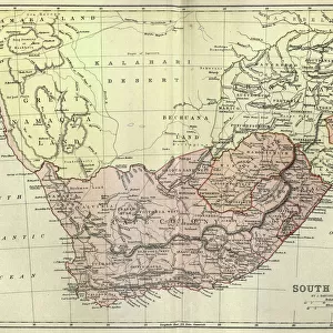
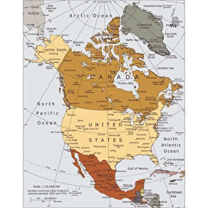
Map of Colonial Africa, from a school book, published in 1911 (colour litho)
")
![]()
Wall Art and Photo Gifts from Fine Art Finder
Map of Colonial Africa, from a school book, published in 1911 (colour litho)
CHT176827 Map of Colonial Africa, from a school book, published in 1911 (colour litho) by Lacoste, Charles (19th century) (after); Private Collection; (add.info.: carte de l Afrique avec des diverses colonies; ); eArchives Charmet; French, out of copyright
Media ID 22916542
© Archives Charmet / Bridgeman Images
Colonies Colonisation Colony Congo Continent Divided Empires Exploitation Nile Plunder Resources
FEATURES IN THESE COLLECTIONS
> Africa
> Egypt
> Related Images
> Arts
> Artists
> I
> Italian School Italian School
> Europe
> Belgium
> Related Images
> Europe
> France
> Canton
> Landes
> Fine Art Finder
> Artists
> Rabindranath Tagore
> Fine Art Finder
> Maps (celestial & Terrestrial)
EDITORS COMMENTS
This print showcases a remarkable piece of history - a Map of Colonial Africa from 1911. The vibrant colours and intricate details bring to life the complex web of colonial empires that once dominated the African continent. Created by Charles Lacoste, this map was originally featured in a school book, serving as an educational tool for students during that era. The map highlights the various colonies established by European powers such as Belgium, France, Italy, England, and Germany. It vividly illustrates how these nations divided and exploited Africa's resources through imperialistic practices. From the vast Congo River to the majestic Nile, every inch of land was subject to plunder and control. This image serves as a reminder of the dark period in history when colonialism reigned supreme. It symbolizes not only the territorial ambitions but also the cultural clashes between African societies and their European colonizers. As we reflect upon this photograph today, it is crucial to acknowledge its significance beyond mere aesthetics. It prompts us to question our past actions while urging us to learn from them. This print stands as a testament to humanity's capacity for both progress and exploitation - reminding us never to forget or repeat our mistakes.
MADE IN THE USA
Safe Shipping with 30 Day Money Back Guarantee
FREE PERSONALISATION*
We are proud to offer a range of customisation features including Personalised Captions, Color Filters and Picture Zoom Tools
SECURE PAYMENTS
We happily accept a wide range of payment options so you can pay for the things you need in the way that is most convenient for you
* Options may vary by product and licensing agreement. Zoomed Pictures can be adjusted in the Cart.