Home > Europe > France > Canton > Landes
Globe Oceania, True Colour Satellite Image. Earth. True colour satellite image of the Earth, centred

![]()
Wall Art and Photo Gifts from Design Pics
Globe Oceania, True Colour Satellite Image. Earth. True colour satellite image of the Earth, centred
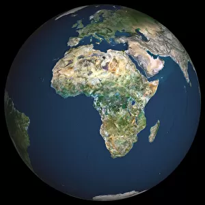
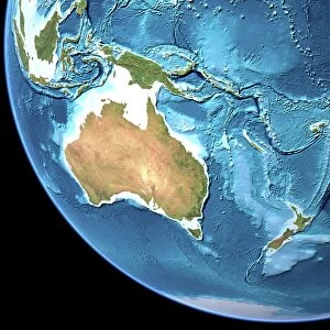
Globe Oceania, True Colour Satellite Image. Earth. True colour satellite image of the Earth, centred on the region of Oceania. North is at top. Water is blue, vegetation is green, arid areas are brown, and snow and ice are white. Both land and ocean floor topography are shown. Shallow coastal waters are light blue. Oceania consists of small islands scattered around the western Pacific Ocean. Archipelago (centre left). Australia (lower left), New Zealand (lower right), part of mainland Asia (top left), the Mala and Antarctica (bottom centre), are also seen. Deserts are seen in the Australian interior, and tropical forests along the Australian coast and in the islands of the Malay Archipelago. The image used data from LANDSAT 5 & 7 satellites. Print size 42x42cm
Design Pics offers Distinctively Different Imagery representing over 1,500 contributors
Media ID 24589217
© UIG / Design Pics
Australia Continent Environment Geographic Illustration Globe Indonesia New Zealand Oceania Satellite Image Uig Premium 1 Uig1 Satellite And Aerial World
FEATURES IN THESE COLLECTIONS
> Aerial Photography
> Australia
> Aerial Photography
> Related Images
> Arts
> Landscape paintings
> Forest and woodland scenes
> Forest artwork
> Asia
> Indonesia
> Related Images
> Design Pics
> Design Pics Art
> Design Pics
> Universal Images Group
> Design Pics
> Update - March 23, 2022
> Europe
> France
> Canton
> Landes
> Maps and Charts
> World
EDITORS COMMENTS
This stunning print captures the true colors of our beautiful planet Earth, with a focus on the region of Oceania. The image, centred on this diverse and vibrant part of the world, showcases the breathtaking landscapes and waters that make up Oceania. From top to bottom, we can see the vast expanse of blue representing the surrounding oceans, while green hues depict lush vegetation covering various islands. Brown shades highlight arid areas, giving us a glimpse into both the harshness and beauty of these regions. White patches symbolize snow-capped mountains and icy terrains. The intricate details in this print go beyond land surfaces; it also reveals ocean floor topography with shallow coastal waters appearing as light blue tones. As we explore further within this image, we can spot an archipelago at its center left along with notable countries like Australia (lower left), New Zealand (lower right), Indonesia (top left), Papua New Guinea (center), and even parts of mainland Asia. This satellite image was created using data from LANDSAT 5 & 7 satellites - a testament to human ingenuity in capturing such awe-inspiring views from space. With a print size measuring 42x42cm, it allows you to immerse yourself in these remarkable details that showcase our planet's diversity and natural wonders. Whether you're an avid traveler or simply appreciate nature's magnificence, this print is sure to captivate your imagination.
MADE IN THE USA
Safe Shipping with 30 Day Money Back Guarantee
FREE PERSONALISATION*
We are proud to offer a range of customisation features including Personalised Captions, Color Filters and Picture Zoom Tools
SECURE PAYMENTS
We happily accept a wide range of payment options so you can pay for the things you need in the way that is most convenient for you
* Options may vary by product and licensing agreement. Zoomed Pictures can be adjusted in the Cart.